Well done to all those involved in drafting the Athy Local Area Plan 2021-2027. Looking at the Plan, I would suggest that the local authority must pay particular attention to the areas of Housing and...
11. Implementation
Dúnta17 Nol, 2020, 07:00 - 8 Fea, 2021, 17:00
Aims:
- To phase new development to ensure that it occurs in an orderly and efficient manner in accordance with the principles of proper planning and sustainable development.
- To ensure that all new residential development and infill development occurs in tandem with the delivery of supporting physical and social infrastructure.
11.1 Implementation Strategy
This Local Area Plan sets out a clear and strategic vision for the development of Athy in the period to 2027 and beyond. This vision is in accordance with the role identified for Athy at both county and regional levels and seeks to make that town a more attractive place to live, work, visit and invest in.. In order for the vision to be realised it is critical that the projected population growth is accompanied by the delivery of the necessary site servicing and social infrastructure requirements. The identification of critical infrastructure that needs to be delivered in tandem with the planned development of the town forms the basis of the following documents:
- Sustainable Planning and Infrastructural Assessment (SPIA)
- Athy Social Infrastructure Audit (SIA)
- Athy Area Based Transport Assessment (ABTA)
These audits and assessments provide a strong evidence base which has informed key policy objectives and provisions of this Plan, including the Phasing and Infrastructure Delivery Schedule for new residential development lands, as outlined in Section 11.3. This seeks to ensure that such development in a sustainable and co-ordinated manner in order to maximise integration of new residential neighbourhoods into the existing community.
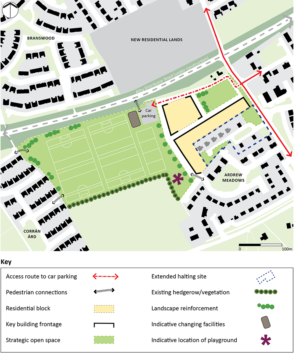
This chapter also contains an urban design brief and framework map for lands at Ardrew which the Plan has designated a Key Development Area. These lands, which are under the ownership of Kildare County Council, are also designated to be the location of a proposed ‘Sports Training Hub’. This new facility is considered to form an essential component of the future recreation and amenity infrastructure of the town (see Section 11.2).
Lastly, this chapter outlines the Land Use Zoning Objectives for Athy (Section 11.4) along with the Land Use Zoning Matrix (Section 11.5)
11.2 Ardrew Key Development Area
The Ardrew Key Development Area (KDA) is considered to constitute a strategic site within the town. Whilst, a portion of the lands, has the capacity to accommodate some residential development, the majority (circa 5 ha) of the KDA will be set aside for the development of a future sports training hub.
The design brief (Table 11.1) and urban design framework (Figure 11.1) illustrates an overarching design concept for the lands which has been based on an appraisal of area and its surrounding contextual environment. It is intended to set out the broad parameters for the development of the site and is designed to assist all parties involved in the planning process including the Council, design teams and residents. While the principal access points, pedestrian connections and key building frontages should generally be regarded as fixed requirements, a degree of flexibility will apply. This takes into consideration any design or on-site issues which may arise. Key building frontages and the layout of the urban blocks may also be varied where it is demonstrated that there is a strong urban design rationale and that passive supervision of public spaces will not be compromised (see Table 11.1, below).
Table 11.1: Ardrew Key Development Area Design Brief
|
Vision To develop the lands for infill residential development and facilitate the creation of a ‘sports training hub’ which will incorporate various passive and active recreational facilities, whilst also providing a much needed training space for clubs in western part of the town. |
|
Connectivity/ Movement Vehicular access to the KDA will be via a single point of entry from Fortbarrington Road which borders the east of the site. The main vehicular route through the lands will also provide access to a car parking area which will service the ‘sports training hub’. The KDA should provide for a high quality permeable form, which integrates with surrounding residential areas, allowing ease of access to what will be an important recreational and amenity space. It is crucial that options for potential connections to future development sites surrounding the KDA are not closed off. All roads and streets in the KDA should be designed in accordance with the Design Manual for Urban Roads and Streets (DMURS). |
|
Built Form Whilst only covering a portion of the site, the built form should provide for a legible development which has regard to the residential amenity of the existing neighbourhood. The built form should provide for a strong level of passive supervision both around dedicated open spaces areas and along the interface with the sports training hub lands. This site will generally accommodate a density in the order of 30 units per hectare. It is noted that the urban design framework for the KDA incorporates the proposed extension to the halting site to the southeast. As provided for by the provisions of the Local Area Plan regarding special needs housing (see Section 4.4), the extended halting site will be accommodating a reduced level of density. |
|
Landscape and Spaces Provide for a minimum of 15% quality open space within the residential lands. Retain as far as possible, the existing green infrastructure (i.e. trees and hedgerows and mature vegetation) in the KDA, as outlined in Map 4: Green Infrastructure. An indicative layout of the training hub is provided which is intended to show the possible sports facilities that could be accommodated on the site. |
Figure 11.1: Ardrew KDA Urban Design Framework
11.3 Phasing and Infrastructure Delivery Schedule
The development of new residential areas within this Local Area Plan will be dependent on the timely delivery of a wide range of infrastructure. The Sustainable Planning and Infrastructure Assessment (SPIA) which accompanies the Plan provides an assessment of transportation, water and wastewater utilities, community and social infrastructure and services that will be required for the development of the KDA lands. Table 11.2 sets out the key infrastructure necessary and funding sources, in a staged delivery schedule, in order to achieve the timely delivery of the objectives of the Athy Local Area Plan 2021-2027.
The outputs of the sustainable planning and infrastructural assessment have informed the overall development strategy and the policies and objectives of the Draft Athy Local Area Plan, specifically the zoning proposals for lands zoned ‘C: New Residential’. The Plan seeks to ensure that the required infrastructural and site-servicing requirements for these lands, as outlined in the SPIA and the Area Based Transport Assessment, are delivered prior to or in tandem with development of these sites, where appropriate and reasonable.
Note: In relation to childcare provision all new residential development in the town including on the sites below is required to provide the pro rata childcare requirements as outlined in Objective HCO3.3 of this Plan and in the Kildare County Development Plan.
The lifetime of this Plan is six years, and the delivery schedule is divided into several phases with the delivery plan of servicing infrastructure to be carried out during the plan period and beyond:
Immediate term Year 1 and Year 2
Short term Year 3 to Year 4
Medium term Year 5 to Year 6
Long term 7 years +
On-going Throughout the plan lifetime and beyond
Table 11.2: KDA Phasing, Infrastructure, Delivery Schedule and Expected Funding Sources
| C: New Residential – Chanterlands | ||
|---|---|---|
| Infrastructure | Delivery Schedule | Funding Sources |
| Roads and Transportation | ||
| Implement measures identified in the Athy Area Based Transport Assessment (ABTA) and the Athy Local Area Plan 2021-2027. | Medium – Long Term - In tandem with new development. | Developer, State, KCC |
| General cycling infrastructure improvements. | On-going - In tandem with new development. | Developer, State, KCC |
| New junction for pedestrian/cycle traffic onto the Athy Distributor Road and access to paths along the River Barrow. | On-going - In tandem with new development. | Developer, State, KCC |
| Water and Wastewater | ||
| Sewers and watermains in estate immediately to the west (10 metres) but would have to be reviewed for suitability. Downstream combined sewer to be checked | On-going – Subject to IW agreement prior to development. | Developer, State (IW) |
| Town centre drainage upgrade works planned but no project yet. | Medium – Long Term | Developer, State (IW) |
| Drainage, SuDs and Flooding | ||
| No known fluvial flood risk on this site. | On-going - In tandem with new development. | Developer, State, KCC, (OPW) |
| Open Space Provision | ||
| Provision of open space and recreational areas | To be carried out in tandem with new development and completed prior to the occupation of all units. | Developer |
| C: New Residential – Adjacent to the Primary Care Centre | ||
|---|---|---|
| Infrastructure | Delivery Schedule | Funding Sources |
| Roads and Transportation | ||
| Implement measures identified in the Athy Area Based Transport Assessment (ABTA) and the Athy Local Area Plan 2021-2027. | Medium – Long Term - In tandem with new development. | Developer, State, KCC |
|
Recent Primary Care Centre development set back boundary which allows for a 3-metre-wide combined walkway/ cycleway. This site already has linkage to New N78 section/ M9. Once Carlow Road is rerouted it will have nearby access to the Athy Distributor Road |
Complete | Developer, State, KCC |
| Water and Wastewater | ||
| Site is not serviced nearest sewer is 150m in adjoining estate to the west. However, this goes into a combined sewer downstream that could be constrained. There is a watermain 80m to the east of the north of the site. | On-going – Subject to IW agreement prior to development. | Developer, State (IW) |
| Drainage, SuDs and Flooding | ||
| No known fluvial flood risk on this site. | On-going - In tandem with new development. | Developer, State (IW) |
| Open Space Provision | ||
| Provision of open space and recreational areas | To be carried out in tandem with new development and completed prior to the occupation of all units. | Developer |
| C: New Residential – Tomard | ||
|---|---|---|
| Infrastructure | Delivery Schedule | Funding Sources |
| Roads and Transportation | ||
| Implement measures identified in Athy Area Based Transport Assessment and the Athy Local Area Plan 2021-2027. | Medium – Long Term - In tandem with new development. | Developer, State, KCC |
| General cycling infrastructure improvements. |
On-going – in tandem with new development. |
Developer, State, KCC |
| Water and Wastewater | ||
| Sewer and watermains in adjacent housing estates but would have to be reviewed for suitability. Combined sewers to the south could be constrained | On-going – Subject to IW agreement prior to development. | Developer, State (IW) |
| Town centre drainage upgrade works planned but no project yet. | Medium – Long Term | Developer, State (IW) |
| Drainage, SuDs and Flooding | ||
|
Fluvial flooding30 in higher return periods31 along the line of the stream at the site boundary. It may be possible to mitigate the flood risk through the construction of a flood risk management scheme. This would require a site-specific assessment and a catchment-based approach which would demonstrate that the mitigation of any existing risk would not result in increased flood risk elsewhere. There are no plans to reduce the flood risk on these lands as the OPW will only provide funding when existing properties are at risk. |
On-going - In tandem with new development. | Developer, State (IW) |
| Open Space Provision | ||
| Provision of open space and recreational areas. | To be carried out in tandem with new development and completed prior to the occupation of all units. | Developer |
| C: New Residential and F: Open Space and Amenity – Ardrew Key Development Area | ||
|---|---|---|
| Infrastructure | Delivery Schedule | Funding Sources |
| Roads and Transportation | ||
| Implement measures identified in the Athy Area Based Transport Assessment and the Athy Local Area Plan 2021-2027. | Medium – Long Term - In tandem with new development. | Developer, State, KCC |
| General cycling infrastructure improvements. | On-going - In tandem with new development. | Developer, State, KCC |
| Water and Wastewater | ||
| Dependent on-site levels, there is a 225 sewer in the road to the east of the site. Also, a watermain is present. | On-going subject to agreement with IW. | Developer, State (IW) |
| Drainage, SuDs and Flooding | ||
| No known fluvial flood risk on this site. | On-going - In tandem with new development. | Developer, State, KCC, (OPW) |
| Open Space Provision | ||
| Ensure provision is in line with the design bridge and urban design framework provided in section 11.2 of the Athy Local Area Plan 2021-2027. | On-going - To be carried out in tandem with new development and completed prior to the occupation of all units. | Developer, State, KCC |
| C: New Residential – Blackparks | ||
|---|---|---|
| Infrastructure | Delivery Schedule | Funding Sources |
| Roads and Transportation | ||
| Implement measures identified in Athy Area Based Transport Assessment and the Athy Local Area Plan 2021-2027. | Medium – Long Term - In tandem with new development. | Developer, State, KCC |
|
General cycling infrastructure improvements. Improvements needed to Fortbarrington Road L8990, localised where new Athy Distributor Road crosses L8990. Site will be accessed by car from the Fortbarrington Road only, protecting the capacity of the new distributor road |
On-going – In tandem with new development. | Developer, State, KCC |
| Water and Wastewater | ||
| No IW Sewer, adjacent to this site (not on GIS) Could link in with site no. 5 to the south, dependent on site levels or longer route down the road. Watermain in road to the east. | On-going subject to agreement with IW. | Developer, State (IW) |
| Drainage, SuDs and Flooding | ||
| No known fluvial flood risk on this site. | On-going - In tandem with new development. | Developer, State, KCC, (OPW) |
| Open Space Provision | ||
| Provision of open space and recreational areas | To be carried out in tandem with new development and completed prior to the occupation of all units. | Developer |
11.4 and Use Zoning Objectives
The land use zoning objectives for Athy are illustrated on Map 6 and should be read in conjunction with Table 11.3 Land Use Zoning Objectives, Table 11.4 Definition of Terms and Table 11.5 Land Use Zoning Matrix.
Table 11.3: Land Use Zoning Objectives
|
Ref |
Use |
Land-Use Zoning Objectives |
|
A |
Town Centre |
To protect, improve and provide for the future development of the town centre. |
|
B |
Existing Residential / Infill |
To protect and enhance the amenity of established residential communities and promote sustainable intensification. |
|
C |
New Residential |
To provide for new residential development. |
|
E |
Community and Educational |
To provide for education, recreation, community and health. |
|
F |
Open Space and Amenity |
To protect and provide for open space, amenity and recreation provision. |
|
N |
Neighbourhood Centre |
To provide for new/existing neighbourhood centres and associated facilities. |
|
H |
Industrial and Warehousing |
To provide for industry, manufacturing, distribution and warehousing. |
|
I |
Agricultural |
To retain and protect agricultural uses. |
|
Q |
Enterprise and Employment |
To provide for and facilitate the provision of high job-generating uses.32 |
|
L |
Leisure and Amenity |
To provide for tourism and leisure facilities. |
|
U |
Transport and Utilities |
To provide for the needs of transport and utility uses. |
|
SR |
Strategic Reserve |
To protect strategic lands from inappropriate forms of development which would impede the orderly expansion of the strategic urban centre. |
Table 11.4: Zoning Matrix – Definition of Terms
|
Term |
Definition |
|
Permitted in Principle (Y) |
Land uses designated under each zoning objective as 'Permitted in Principle' are generally acceptable, subject to compliance with those objectives as set out in other chapters of this Plan. |
|
Open for Consideration (O) |
Land uses shown as 'Open for Consideration' are uses that are not considered acceptable in principle in all parts of the relevant land use zone. However, such uses may be acceptable in circumstances where the Council is satisfied that the proposed use would not conflict with the general objectives for the zone and the permitted or existing uses as well as being in the interests of the proper planning and sustainable development of the area. |
|
Not Permitted (N) |
Land uses which are indicated as 'Not Permitted' in the Land Use Zoning Matrix (see Table 11.4) will not be permitted. |
|
Other Uses |
Proposed land uses not listed in the matrix will be considered on the merits of the individual planning application, with reference to the most appropriate use of a similar nature indicated in the table and in relation to the general policies and zoning objectives for the area. |
|
Non-conforming uses |
Existing established uses that are inconsistent with the primary zoning objective, where legally established by continuous use for the same purpose prior to 1st October 1964 or by a planning permission and will not be subject to legal proceedings under the Act in respect of their continued use. Where extensions or improvements of premises accommodating these uses are proposed each shall be considered on its merits in accordance with the proper planning and sustainable development of the area. |
|
Transitional Areas |
While the zoning objectives indicate the different uses permitted in each zone it is important to avoid abrupt transitions in scale and use at the boundary of adjoining land use zones. In these areas it is necessary to avoid developments that would be detrimental to amenity. In zones abutting residential areas, particular attention will be paid to the uses, scale, density and appearance of development proposals and to landscaping and screening proposals in order to protect the amenities of residential properties. Development abutting amenity and open space will generally facilitate the passive supervision of that space, where possible by fronting onto it. |
11.5 Land Use Zoning matrix
The land use zoning objectives for Athy are illustrated on Map 6 and should be read in conjunction with Table 11.2 Land Use Zoning Objectives, Table 11.3 Definition of Terms, and Table 11.4 Land Use Zoning Matrix, below.
Note: Scroll horizontally to read the table or download a PDF version here.
|
Land Use |
A – Town Centre |
B - Existing Residential/Infill |
C – New Residential |
E – Community and Educational |
F – Open Space and Amenity |
N – Neighbourhood Centre |
H - Industrial and Warehousing |
I - Agriculture |
Q – Enterprise & Employment |
L – Leisure and Amenity |
U – Transport and Utilities |
|
Amusement Arcade |
O |
N |
N |
N |
N |
N |
N |
N |
N |
N |
N |
|
Agricultural Buildings |
N |
N |
N |
N |
N |
N |
O |
Y |
N |
N |
N |
|
Car Park (other than ancillary) |
Y |
N |
N |
O |
N |
O |
O |
N |
O |
O |
O |
|
Betting Office |
O |
N |
N |
N |
N |
O |
N |
N |
N |
N |
N |
|
Cemetery |
N |
N |
N |
Y |
N |
N |
N |
O |
N |
N |
N |
|
Cinema |
O |
N |
N |
N |
N |
N |
N |
N |
N |
N |
N |
|
Community / Recreational / Sports buildings |
Y |
O |
O |
Y |
Y |
O |
N |
O |
N |
Y |
N |
|
Crèche / Playschool |
Y |
O |
Y |
Y |
N |
O |
N |
N |
O |
O |
N |
|
Cultural Uses / Library |
Y |
O |
O |
Y |
O |
O |
N |
N |
N |
O |
N |
|
Dancehall / Disco |
O |
N |
N |
N |
N |
N |
N |
N |
N |
O |
N |
|
Dwelling |
Y |
Y |
Y |
O33 |
N |
O |
N |
O34 |
N |
N |
N |
|
Emergency Residential Accommodation |
Y |
O |
O |
Y |
N |
Y |
N |
N |
N |
O |
N |
|
Funeral Homes |
Y |
N |
N |
O |
N |
O |
N |
N |
N |
N |
N |
|
Garage / Car Repairs |
N |
N |
N |
N |
N |
N |
Y |
N |
N |
N |
N |
|
Group / Special Accommodation Needs35 |
Y |
Y |
Y |
O |
N |
O |
N |
O |
N |
N |
N |
|
Guest House/Hotel/Hostel |
Y |
O |
O |
N |
N |
O |
N |
O |
N |
Y |
N |
|
Heavy Commercial... |
N |
N |
N |
N |
N |
N |
Y |
N |
N |
N |
O |
|
Hot Food take away |
O |
N |
N |
N |
N |
O |
N |
N |
N |
N |
N |
|
Industry (Light) |
O |
N |
N |
N |
N |
N |
Y |
N |
O |
N |
N |
|
Industry (General) |
N |
N |
N |
N |
N |
N |
Y |
N |
N |
N |
O |
|
Medical Consultant / Health Centre |
Y |
O |
O |
Y |
O36 |
Y |
N |
N |
O |
O |
N |
|
Motor Sales |
O |
N |
N |
N |
N |
N |
Y |
N |
N |
N |
N |
|
Nursing Home |
Y |
Y |
Y |
O |
N |
N |
N |
O |
N |
N |
N |
|
Offices |
Y |
O37 |
O5 |
N |
N |
O |
O |
N |
O |
N |
N |
|
Park / Playground |
Y |
Y |
Y |
Y |
Y |
O |
N |
O |
N |
Y |
N |
|
Petrol Station |
N |
N |
O |
N |
N |
O |
Y |
N |
O |
N |
O |
|
Place of Worship |
Y |
O |
O |
Y |
N |
O |
N |
N |
N |
O |
N |
|
Playing Fields |
O |
O |
O |
Y |
Y |
N |
N |
O |
O |
Y |
N |
|
Pub |
Y |
N |
O |
N |
N |
O |
N |
N |
N |
O |
N |
|
Restaurant |
Y |
O |
O |
N |
N |
O |
N |
N |
O |
O |
N |
|
School |
Y |
O |
O |
Y |
O |
N |
N |
N |
N |
N |
N |
|
Shop (Comparison) |
Y |
N |
N |
N |
N |
N |
N |
N |
N |
N |
N |
|
Shop (Convenience) |
Y |
O38 |
O6 |
N |
N |
O39 |
N |
N |
O7 |
N |
N |
|
Stable Yard |
N |
N |
N |
N |
O |
N |
N |
Y |
N |
N |
N |
|
Tourist Related Facilities |
Y |
O |
O |
O |
O |
O |
N |
O |
N |
O |
N |
|
Utility Structures |
O |
O |
O |
O |
O |
O |
O |
O |
O |
O |
Y |
| Warehouse (Wholesale) / Store / Depot | O | N | N | N | N | N | N | N | N | N | N |
- 30- Fluvial flooding occurs when rivers and streams break their banks and water flows out onto the adjacent low-lying areas (the natural floodplains). This can arise where the runoff from heavy rain exceeds the natural capacity of the river channel and can be exacerbated where a channel is blocked or constrained or, in estuarine areas, where high tide levels impede the flow of the river out into the sea. https://www.floodinfo.ie/about_frm/types_and_causes/ (OPW)
- 31- A Return Period is the period the estimated average time between flood events (e.g. the 100-year flood), although it is noted this period may not be the length of time that will elapse between two such events occurring (e.g. two 100-year floods may occur within the period of 5 years rather than once every 100 years). https://www.floodinfo.ie/about_frm/types_and_causes/ (OPW)
- 32- Note: This zoning designation takes into consideration the development of Athy Food, Drinks and Skills Innovation Hub which will be located at the former Model School site. The proposed hub will also have ancillary training and education facilities. Such a provision is supported by Objective EDTO1.12 (Chapter 6 Economic Development, Enterprise and Tourism).
- 33- Ancillary to health/community use, and/or to meet special accommodation needs.
- 34- Subject to Rural Housing Policy as outlined in the Kildare County Development Plan.
- 35- For further information on group/special accommodation needs refer to Section 4.4.1 of this Plan.
- 36- Only where the existing Open Space and Amenity can be offset to a suitable alternative site.
- 37- Proposals of this nature shall be restricted to circa 100m2 .
- 38- No single unit shall exceed 100 m2 of the net retail space.
- 39- No single unit shall exceed 200 m2 of the net retail space to a maximum number of three units. The total net retail space shall not exceed 300 m2.
Clár ábhair
Ábhair
Tuarascálacha
Tuairimí
Tuairimí
Residential Infill and Unfinished Housing Estates
Please see attached submission for details.
Town Centre Land - Appropriate Zoning
Please see attached submission for details.
I am asking the following
I own the house and property adjacent to the proposed New playing fields and housing development referred to in the plan as Ardrew Key Development area.
If this proposed development goes to...