The settlement boundary of the Athy Town Development Plan, 2012-2018 should be retained as is. This boundary protects the "Environs" of the town from inappropriate development.
The...
10. Infrastructure and Environmental Services
Dúnta17 Nol, 2020, 07:00 - 8 Fea, 2021, 17:00
Aim: To ensure that future residential, employment and commercial growth in Athy occurs in tandem with the delivery of supporting physical infrastructure whilst also incorporating appropriate climate change mitigation and adaptation measures.
The availability of high quality infrastructure networks and environmental services is critical to securing investment, creating sustainable and attractive places, ensuring the health and well-being of the community and safeguarding the environment. In this regard, a Sustainable Planning and Infrastructural Assessment (SPIA) was carried out to inform the appropriate zoning of land and has been published alongside this Local Area Plan.
10.1 Water Supply and Wastewater
Irish Water is responsible for the provision of public water services (water supply and foul drainage) on a national basis. Irish Water is mandated to provide both drinking water and wastewater capacity to facilitate future settlement growth, in line with national and regional planning policies and objectives, subject to the availability of funding, environmental and financial sustainability criteria. Kildare County Council retains its role in facilitating the provision of adequate water services, in conjunction with Irish Water, at a local level, through a Service Level Agreements (SLA).
In 2015 Irish Water published its Water Services Strategic Plan (WSSP), which sets out strategic objectives for the delivery of water services over a 25-year period and a context for investment and implementation plans. Irish Water and Kildare County Council will continue to work together to identify the water services required to support planned development in line with national and regional planning policies for inclusion in the Irish Water Capital Investment Plans.
Irish Water is currently preparing a National Water Resources Plan (NWRP). This strategic plan for water services will outline moves towards a sustainable, secure and reliable public drinking water supply over the next 25 years, whilst safeguarding the environment. The NWRP will outline how Irish Water intends to maintain the balance between the supply from water sources around the country and the demand for drinking water over the short, medium and long term. This will allow planning for the future and ensure the provision of sufficient safe, clean drinking water to facilitate the social and economic growth of Ireland. Kildare County Council will work with and support Irish Water in delivering the NWRP.
10.1.1 Water Supply
Census 2016 records that 92.5% of all households in the settlement of Athy are connected to the public mains network. The average water demand in the town is 3 million litres per day, as of Summer 2020. Since 2013 Athy has been served by the Srowland Water Treatment Plant located the north of the town. This plant replaced all four previous sources and has the capacity to serve 11,000 population equivalent (PE). While there are no specific constraints on the water supply network Irish Water (IW) advises that there is limited capacity at the treatment works and new connections will be on a first come/first served basis. It is noted that capacity will have to be expanded to accommodate the envisaged growth in the town over the life of the Plan.
10.1.2 Wastewater
Census 2016 records that 91.3% of all households in the settlement of Athy are connected to the public sewerage scheme network. Wastewater is treated at the Athy Wastewater Treatment Plant at Fortbarrington Road located to the southwest of the town centre. The plant has an existing design capacity of 15,000PE with capacity for future expansion.
Figures from 2019 show the loading recorded as 12,898PE leaving a treatment capacity of 2,102PE. It is noted that there are no major infrastructural constraints on the foul sewer network within the town. However, it is anticipated that it will be necessary to extend the plant to beyond 15,000PE before 2027 to meet the envisaged additional domestic and non-domestic demand within the town.
Policy I1 – Water Supply and Waste WaterI1 It is the policy of the Council to work in conjunction with Irish Water to protect existing water and wastewater infrastructure in Athy, to maximise the potential of existing capacity and to facilitate the timely delivery of new water services infrastructure to facilitate future growth. Objectives It is an objective of the Council to: 101.1 Work in conjunction with Irish Water to promote the ongoing upgrade and expansion of water supply and wastewater services to meet the future needs of Athy. 101.2 Maximise the sustainable and efficient use of existing capacity in water services in the planning of new development. 101.3 Seek to ensure that adequate water services will be available to service development prior to the granting of planning permission for development. 101.4 Seek to ensure that development proposals comply with the standards and requirements of Irish Water in relation to water and wastewater infrastructure. |
10.2 Surface Water and Ground Water
The management of surface water and protection of groundwater is an integral part of Kildare County Council's sustainable water services policy. Adequate storm water drainage and retention facilities are necessary to accommodate surface water run-off resulting from current and future developments in Athy. The use of Sustainable Drainage Systems {SuDS} and the provision/safeguarding green infrastructure in new developments is considered to be critical in contributing to surface water retention and consequently help to prevent and mitigate the effects of flooding, by aiding the natural drainage of a site. As noted in Section 2.2 such measures are considered to be an essential part of mitigating the effects of climate change and creating a more climate resilient town.
The central objective of the EU Water Framework Directive {WFD}, to protect and restore good water quality, is carried out through the implementation of River Basin Management Plans in Ireland. Athy is located within the South Eastern River Basin District. This Water Management Unit contains the River Barrow, the Corran Ard stream, the Moneen Stream and the Grand Canal waterbodies. The Environmental Protection Agency {EPA} notes the River Barrow as having a 'Good' quality status just north of the town, while to the south of the town, the Barrow along with the Corran Ard stream is recorded as having 'Poor' water quality status.25
The EPA has designated the groundwater within the area within the boundaries of the Local Area Plan as having a 'Good' quality status.26 In relation to groundwater risk, the EPA exams water quality and trends on an ongoing basis. Such data is used to highlight waterbodies that are at risk of deteriorating or being at less than 'Good' status in the future. In this regard, the majority of the area covered by the Local Area Plan is categorised as 'Not at Risk' but an area to the northwest of the town designated as in need of review.
The objective of the Plan is therefore to protect both surface waterbodies and groundwater aquifers from further deterioration and maintain or where necessary improve their quality over the period of the Local Area Plan and beyond.
Policy I2 – Surface Water and GroundwaterI2 It is the policy of the Council to maintain and enhance the existing surface water drainage systems in Athy and to protect surface and ground water quality in accordance with the Water Framework Directive. Objectives It is an objective of the Council to: IO2.1 Carry out an audit of the existing surface water infrastructure to identify improvement works as required. IO2.2 Ensure that all new developments maintain surface water discharge at greenfield runoff rate, including an allowance for climate change. IO2.3 Incorporate Sustainable Urban Drainage Systems (SuDS) and other nature-based surface water drainage solutions as part of all plans and development proposals in Athy. Priority shall be given to SuDS that incorporate green infrastructure and promote biodiversity including green roofs, walls and rain gardens. Proposals for all new residential developments and for the development of ‘H’ and ‘Q’ zoned employment lands must consider the potential for SuDS to control surface water outfall and protect water quality, with underground retention solutions only being considered when all other options have been exhausted. IO2.4 Maintain, improve and enhance the environmental and ecological quality of surface waters and groundwater in Athy in accordance with the River Basin Management Plan for Ireland and in conjunction with the Environmental Protection Agency. IO2.5 Require applicants, where necessary, to demonstrate that proposals will not negatively impact on any groundwater or surface water body and be compliant with the requirements of the Water Framework Directive and measures to protect and improve our water bodies set down in the River Basin Management Plan for Ireland 2018 – 2021 and future Cycles of this Plan. IO2.6 Protect both ground and surface water resources and to work with Irish Water to develop and implement Water Safety Plans to protect sources of public water supply and their contributing catchments. IO2.7 Ensure that development along urban watercourses must comply with the Inland Fisheries Ireland Guidance ‘Planning for Watercourses in the Urban Environment’ (2020), including the maintenance of a minimum riparian zone of 35 metres for river channels greater that 10 metres in width, and 20 metres for rivers channels less than 10 metres in width. Development within this zone will only be considered for water compatible developments.27 Action
|
10.3 Flood Risk Management
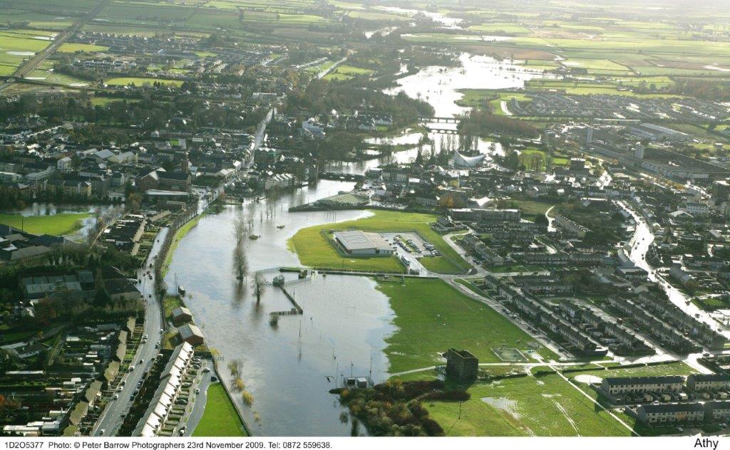
While it is noted that Athy is vulnerable to flooding particularly from the River Barrow (see Figure 10.1), large areas of the floodplains within Athy are currently not built upon. In light of the increasing risk and frequency of flooding due to climate change and the need to achieve resilience within the town to mitigate its effects this Plan has taken measures to ensure these lands remain undeveloped. Floodplains and wetlands subject to flooding are therefore recognised and preserved in the Plan to the maximum extent possible, in both urban and rural areas, as green infrastructure that provides a natural defence against flood risk. In recognition of this and in light of their additional value as ecological corridors, the Plan seeks to develop an integrated Green Infrastructure network which focuses on the waterbodies within Athy, namely the River Barrow and the Grand Canal. These measures are required under the Kildare County Council Climate Adaptation Strategy (2019 - 2024) and integrated throughout the plan (see Section 2.2). Areas susceptible to flooding are identified on Map 2: Athy Flood Risk Map.
Figure 10.1: Flooding event along the River Barrow Floodplain in Athy 2009
A Strategic Flood Risk Assessment (SFRA), as required by the Planning System and Flood Risk Management Guidelines for Planning Authorities (2009) has informed the preparation of the Plan. This Plan avoids development in areas at risk of flooding as identified by the SFRA and has substituted vulnerable land uses with a less vulnerable use where this is not possible. Where neither is possible, mitigation and management of risks must be proposed. Justification tests29 were carried out on a number of sites and are detailed in the SFRA report accompanying this Plan. The SFRA has recommended that development proposals for a number of areas within the plan boundary should be the subject of site-specific flood risk assessment appropriate to the nature and scale of the development being proposed. The SFRA of the Plan is informed by the South Eastern Catchment Flood Risk Assessment and Management (CFRAM) study which was undertaken by the OPW to manage river catchment flooding.
10.3.1 Athy Flood Relief Scheme
The outputs of the CFRAM studies has informed the preparation of various flood risk management plans (FRMPs) to deal with fluvial flood risk in County Kildare, which were adopted by the Council in July 2018. As part of Tranche 1 there is a flood relief scheme (FRS) proposed for Athy. This scheme has been prioritised by the Office of Public Works (OPW) and will provide protection to existing residential and commercial properties at risk from fluvial (river based) flooding to 1% Annual Exceedance Probability (AEP) event standard of protection (roughly equivalent to a 1 in 100-year storm). It is noted that this scheme has and will continue to integrate climate change considerations into its design, planning and construction.
The Council is currently developing a brief for consultancy services for the design of the Athy FRS. The first stage of this brief will include a review of the hydrology and environmental survey. It is likely that the scheme will involve construction of defences along both sides of the River Barrow in the town centre. It is envisaged that these works can be incorporated into landscaping features.
Policy I3 Flood Risk ManagementI3 It is the policy of the Council to manage flood risk in Athy in conjunction with the Office of Public Works and in accordance with the requirements of the Planning System and Flood Risk Management Guidelines for Planning Authorities (2009) and circular PL02/2014 (August 2014). Objective IO3.1 Manage flood risk in Athy in accordance with the requirements of The Planning System and Flood Risk Management Guidelines for Planning Authorities, DECLG and OPW (2009) and Circular PL02/2014 (August 2014). IO3.2 Ensure development proposals within the areas outlined on the Flood Risk Map are the subject of Site-Specific Flood Risk Assessment, appropriate to the nature and scale of the development proposed. IO3.3 Maintain all existing overland flow routes. IO3.4 Support and co-operate with the OPW in delivering the Athy Flood Relief Scheme, subject to the statutory environmental considerations. |
10.4 Energy Supply and Communications
The electricity infrastructure of Athy comprises one 110KV Station at Woodstock South with two associated 110KV lines. There is capacity available in Athy for industries and other demand uses wishing to locate in the town. This Plan seeks to continue to encourage and facilitate the under- grounding of overhead electricity cables in built-up areas, particularly in the town centre, during the lifetime of this Plan.
Athy was linked to the national gas pipeline network in 1999 and is served via a spur from the Cork to Dublin mainline pipe. GAS Networks Ireland (GNI) operates and maintains a modern gas network in Athy. GNI note that there are currently no constraints on the network with maintenance work being regularly undertaken to ensure it continues to run optimally. Gas customers in the town benefit from a reliable network with typically zero downtime. The gas network in Athy currently serves areas of the town where it is economically viable to provide a service. GNI supports the expansion of the gas network within settlements in line with its approved Connections Policy which ensures that any further expansion of the network is completed in an economically feasible manner. As of July 2020, GNI have no plans to expand the gas network in Athy.
Broadband is readily available in Athy from a number of telecoms providers, which have developed a network of infrastructure serving the area and provide various types of connectivity from fixed line to wireless and mobile broadband.
Policy I4 Energy and CommunicationsI4 It is the policy of the Council to promote and facilitate the development and renewal of energy and communications networks in Athy, while protecting the amenities of the town. Objectives It is the objective of the Council to: IO4.1 Support the statutory providers of electricity and gas infrastructure by safeguarding existing infrastructure and strategic corridors from encroachment by development that might compromise the operation, maintenance and provision of energy networks. IO4.2 Support and facilitate the provision of telecommunications infrastructure, including broadband services in Athy, subject to safety and amenity requirements. IO4.3 Seek the undergrounding of all electricity, telephone and television cables within built-up areas in the town. IO4.4 Discourage a proliferation of above ground utility boxes in the town and to seek screening measures in conjunction with the provision of such structures. IO4.5 Promote and encourage the use of renewable energy technologies in existing and proposed building stock within the boundaries of the Local Area Plan subject to consideration of environmental, conservation and visual requirements. Action
|
10.5 Pollution and Environmental Services
It is a priority of this Plan that pollution and environmental services in Athy conform with European, national and regional policy in relation to pollution control (air, noise and light) and waste management and to maintain and improve environmental services and amenities in the town.
Kildare County Council recognises the importance of maintaining the town free from litter and protecting it from indiscriminate dumping and bill postering. Along with fulfilling its statutory obligations, the Council will endeavour to work with the Tidy Towns Committee, schools and local residents’ associations, along organisations such as Waterways Ireland to increase awareness of waste recycling and litter control.
Refuse collection in Athy is currently carried out by a number of private contractors. The Civic Amenity Centre located at Gallowshill, off the Dublin Road, in Athy is operated by AES under license by Kildare County Council. This facility provides a significant service to the local community and accepts a wide range of recyclable materials including glass, paper, cardboard, hazardous household waste, material, plastic and cans. There is also a bring bank recycling facility for bottles and cans located in the car park at Edmund Rice Square in the centre of the town. The Council seeks to expand recycling opportunities in Athy by establishing another local bring bank facility at an appropriate location within the town.
The GEO portal of the Environmental Protection Agency (EPA) (www.epa.ie/EPAMaps under the heading of Health and Wellbeing) maps the air quality levels and noise pollution of the major settlements in the country. Athy is stated as having achieving category ‘1 – Good’ on their air quality index. The portal does not have (as of Summer 2020) any noise pollution maps for the town.
However, Objective HCO2.3 (see Chapter 4) requires that residential schemes in close proximity to heavily trafficked roads within the Plan area should incorporate comprehensive noise mitigation measures into their planning and design.
Policy I5 – Pollution and Environmental ServicesI5 It is the policy of the Council to protect environmental quality in Athy through the implementation of European, national and regional policy and legislation relating to air quality, greenhouse gases, climate change, light pollution, noise pollution and waste management. Objectives It is an objective of the Council to: IO5.1 Adequately maintain recycling facilities and to secure the provision of additional facilities, as required, including in conjunction with development. IO5.2 Support the development of a local bring bank recycling facility at an appropriate location, proximate to either the Stradbally Road or Kilkenny Road, within the boundaries of the Local Area Plan. IO5.3 Avoid, prevent or reduce harmful effects on human health and the environment as a whole through promoting the preservation of best ambient air quality with sustainable development. IO5.4 Support the take-up and use of ultra-low emissions vehicles and encourage, through the development management process the provision of electric vehicle charging infrastructure, where appropriate. |
- 25 Source: www.catchments.ie (the status of the waterbodies is designated in accordance with the WFD and cover the 2013-2018 period)
- 26 Source: www.catchments.ie (the status of the groundwater is designated in accordance with the WFD and cover the 2013-2018 period)
- 27 Water compatible developments as defined in the OPW Planning System and Flood Risk Management Guidelines for Planning Authorities (2009)
- 28 ‘Daylighting’ is the action of returning a culverted river to open water. At its simplest it is taking the lid off the culvert, but most designs aim to create a more natural river shape and re-introduce ecological habitats.
- 29 Justification tests are used to assess the appropriateness of developments in flood risk areas. For further detail, refer to the Strategic Flood Risk Assessment which accompanies the Local Area Plan.
Clár ábhair
Tuarascálacha
Tuairimí
Tuairimí
Indoor Sports Facility Development
Athy Gymnastics Club wish to highlight a significant gap in the proposed sporting facilities noted on the draft Athy LAP. While it is fantastic to see the inclusion of much needed new playing...
The Gas Network, Air Quality and the Natural Environment
GNI is cognisant of the natural environment with an ongoing commitment to biodiversity and archaeology. Transportation of gas is unobtrusive with care taken to minimise the impact on local flora and...
Observations in relation to Water Services
Comments in attached letter
TII Submission to Draft Athy LAP
Covered under TII submission under Chapter 3