Re Submission to Pre-Draft Consultation for the Athy Local Area Plan 2021-2027 concerning Lands at Shamrock Lodge, Athy, Co. Kildare in the ownership of MHL...
03. Compliance with the Core Strategy
Dúnta17 Nol, 2020, 07:00 - 8 Fea, 2021, 17:00
Aim: To accommodate 4.8% of County Kildare’s allocated housing growth in Athy over the period 2021-2027 in accordance with the Core Strategy of the Kildare County Development Plan.
3.1 Function, Population and Scale of Athy
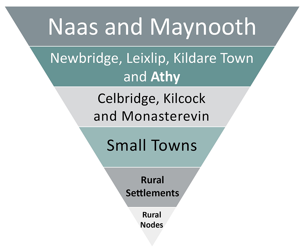
The Core Strategy of the County Development Plan identifies Athy as a ‘Self-Sustaining Growth Town’. This is the second highest level within the settlement hierarchy of the county (see Figure 3.1). Census 2016 recorded Athy to have a population of 9,677 persons.2 The population of the town was relatively unchanged from Census 2011. However, this period of stagnation in the town’s growth followed a prolonged period of rapid population growth in the late 1990s and 2000s, which was not accompanied by a similar increase in employment. In this regard the Plan seeks to deliver a framework for development where the projected population growth is accompanied by targeted investment to improve local services and employment opportunities, in order for Athy to function as a more self-sustaining settlement.
Figure 3.1: Athy within the Kildare Settlement Hierarchy
3.2. Future Housing and Population Targets
Under the Core Strategy of the County Development Plan Athy has been allocated 4.8% of Kildare’s overall housing growth. Applying this figure to the Athy Local Area Plan translates into a requirement for 771 additional units to be built over the life of the Plan to 2027. Using a unit occupancy rate of 2.8 persons per household, as provided for in the Development Plan would result in an increase of 2,160 persons in Athy by the end of the Local Area Plan period (see Tables 3.1 and 3.2, below and overleaf).
Table 3.1: Projected Population Increase to 2027
|
Population Census 2016 |
Allocated Population Increase |
Population target for 2027 |
|
9,677 |
2,160 * |
11,837** |
* The projected increase is based on the allocation in Table 3.3 of the County Development Plan (as varied) which provides for a population increase of 1,890 persons by 2026 and then projected forward by a further year to 2027 in order to coincide with the life of the Local Area Plan i.e. 1,890/7 years (2020-2026) = an increase of 270 persons per annum multiplied by 8 years gives a projected population increase of 2,160 to the end of 2027.
**This figure only includes projected population growth on lands zoned for town centre and new residential uses. It does not include any increases in population on existing residential/infill lands.
Table 3.2: Projected Housing Increase to 2027
|
Housing Units Census 2016 |
Allocated Unit Increase to 2027 |
Total units in 2027 |
|
4,281 |
771* |
5,052 |
* Similar to Table 3.1 the projected increase is based on Table 3.3 of the County Development Plan which allocates an increase of 675 units by 2026. This is then projected forward by another year to 2027 in order to coincide with the life of the Local Area Plan i.e. 675 units/7 years (2020-2026) = an increase of 96 units per annum multiplied 8 years gives a figure of 771 units to the end of 2027.
3.3. Achieving Compact Growth
What is the built-up footprint of a town?The existing built-up footprint of an urban settlement is defined by the CSO (in line with UN criteria) as an area with a minimum of 50 occupied dwellings, with a maximum distance between any dwelling and the building closest to it of 100 metres, and where there is evidence of an urban centre (shop, school etc.). The built-up area of Athy, as defined by its settlement boundary is based on the returns from Census 2016. |
3.3.1. A Tiered Approach to Land Zoning
Appendix 3 of the National Planning Framework (NPF) requires the plan to adopt a Tiered Approach to Land Zoning. On foot of this a Sustainable Planning and Infrastructural Assessment (SPIA) was prepared to assess the suitability of lands for future development. This assessment (published alongside the Plan) provides a weighting of potential sites for future development on the basis of sustainable planning and serviceability/infrastructural grounds. The SPIA assists in the designation of lands as either Tier 1 lands (lands that are already serviced) or Tier 2 lands (lands that are serviceable within the life of the plan) and identifies the likely development services required to support new development. An indicative timeframe for delivery of critical infrastructure i.e. short, medium term or long term is also provided. Potential employment lands have also been included in the assessment. The SPIA is considered to be another important tool in delivering consolidated and sequential development within Athy and has informed Section 3.4 Estimated Residential Capacity.
3.3.2. Active Land Management
The dynamics of the housing and rental market in Athy have altered greatly over the past number of years. Figures from the 2016 Census recorded a residential vacancy level of 12.5% (1 in 8 properties) and recorded only 34 residential units being constructed in the town between 2011 and 2016.4
Whilst Athy may have been slower to recover from the early 2010’s recession than other parts of the county, and consequently slower to suffer from the effects of the housing crisis, this situation has changed and due to the shortage of properties and the increase in rents, the town was designated a rent pressure zone (RPZ) in April 2020.5
There is a need to deliver the housing units allocated to Athy during the life of the plan. In order to ensure such development is sustainable, it is considered that an active land management approach on behalf of the local authority is critical to achieving the delivery of a continuous supply of new housing in the town in a consolidated and sequential manner.
|
The Plan, through its various policies, objectives and actions incorporates the following active land management provisions:
|
3.3.3 Building Heights
The guidelines Urban Development and Building Heights: Guidelines for Planning Authorities (DHPLG, 2018) contain a number of mandatory Specific Planning Policy Requirements (SPPRs) which local authorities are obliged to provide for when making their statutory plans. Of particular relevance to this Plan is SPPR 1 which requires local authorities explicitly to identify areas where increased building height will be actively pursued for both redevelopment, regeneration and infill development and that such plans shall not provide for blanket numerical limitations on building height. Also of relevance is SPPR 4 which requires that the minimum densities set out in the Guidelines for Sustainable Residential Development in Urban Areas (2009) should be met and that a greater mix of building heights and typologies in planning for the future development of suburban locations, in particular in developments of 100 units or more.
Having regard to the requirements outlined, this Local Area Plan does not propose to place any height limitations on new development in Athy. Also, in keeping with the provisions set out in SPPR 1 the following locations are identified as possible locations for taller buildings
- The town centre (with possible sites identified in the Urban Regeneration Framework)
- New Residential lands at Chanterlands (south of the train station)
Taller buildings can, in circumstances where they are well-designed and sited, make a positive contribution to an urban setting, however, particular care must be taken when making such interventions in a town with such a rich historic fabric as Athy which also includes an Architectural Conservation Area (ACA). Due regard must be had to the existing characteristics of the receiving environment. As provided for in the guidelines on building heights (p.13), each proposal will be required to ‘…successfully integrate into/enhance the character and public realm of the area, having regard to topography, its cultural context, setting of key landmarks, protection of key views’.
Increased building heights on new residential lands should be subject to site-specific and design quality appraisals which take into consideration the impact of taller developments on the existing urban fabric in order to ensure that such buildings integrate well with their surroundings.
Whilst the preferred locations of taller buildings have been identified, it should be noted that this Local Area Plan places emphasis on delivering the desired densities at appropriate locations rather than focusing on increasing building heights. Achieving the sustainable residential densities envisaged in Section 3.4 will not require the development of tall buildings in Athy.
3.4 Estimated Residential Capacity
This Plan retains areas of land with extant planning permissions for residential development (261 units) previously zoned for new residential purposes under the Athy Town Development Plan 2012- 2018. Circa 10% (58) of the remaining units have been allocated to town centre lands (see Section 3.3.2). The balance of 452 units required will be provided on approximately 15.6 hectares of additional New Residential zoned lands from an overall residential unit target of 771 units to 2027 (see table 3.3 and 3.4 below).
Table 3.3: Units target to 2027 (less extant permissions)
|
|
Units |
|
Units allocated to Athy in period to 2027 |
771 |
|
Less units developed on new residential lands since 2016 |
0 |
|
Less extant permissions on new residential lands |
261 |
|
Remaining unit target |
510 |
|
Town Centre allocation of c.10% of remaining unit target = |
58 |
Table 3.4: Estimated Residential Capacity
|
Location of Development |
Quantum of Undeveloped Residential Land (in hectares) |
Estimated Residential Capacity (approx. no. of units) |
Density Range* (units per hectare) |
|
Town Centre Development |
|
|
|
|
Town centre infill |
- |
58 |
35-50 (where appropriate) |
|
New Residential Development |
|
|
|
|
Dublin Road |
0.5 |
11 units |
N/A (extant permission) |
|
Clonmullin and Gallowshill |
8.9 |
250 units |
N/A (extant permission) |
|
Tomard |
4.2 |
147 |
35 |
|
Chanterlands |
4.3 |
172 |
35-50 (average 40) |
|
Blackparks |
3.8 |
133 |
35 |
|
Ardrew KDA* |
3.3 |
65 (60 units and 5 halting sites) |
Varying |
|
Sub Total |
25 ha |
- |
|
|
TOTAL (inc. Town Centre infill) |
- |
771 |
|
* There are currently 765 6 cases on the Council Housing List for the town of Athy. Following consultation with the Housing Section during the preparation of this Local Area Plan, it was evident that a substantial number of those on the list are people who are currently resident in the town and therefore do not represent population growth in the context of the Core Strategy. Whilst it is acknowledged that the proposal does not accommodate a significant percentage of those currently awaiting social housing, the PPP (Public-Private Partnership) development at Ardrew KDA, will provide 60 housing units and 5 halting sites (and a sizable recreational facility). It should be noted therefore, that whilst identified in Table 3.4, these units do not form part of the overall new housing target to accommodate population growth in the town. This Plan will also make provision for social housing in the town, through Part V and through supporting housing developments brought forward by Approved Housing Bodies.
The densities estimated for each site in Table 3.4 above are indicative only. It should be noted that any application for development on these lands should adhere to the Guidelines on Sustainable Residential Development in Urban Areas, DEHLG (2009). In any case, the density of development and number of units permissible will be determined at detailed design stage based on a full assessment of site characteristics, local conditions, design sensitivities and the overall quality of the scheme and having regard to the various provisions on development management within the Kildare County Development Plan along with the relevant Section 28 Ministerial Guidelines.
3.5 Compliance with the Core Strategy
To ensure continued compliance with the Core Strategy and its housing allocation for Athy it will be necessary to monitor the number of residential units permitted and developed on an annual basis. The quantum of land zoned in the Local Area Plan is based on an estimated density of specific sites. If that density is significantly increased a surplus of zoned lands is generated which, if developed within the lifetime of the Plan, will result in a greater population than the Core Strategy provided for.
Monitoring the number of units permitted and constructed enables a closer alignment between the Core Strategy, the population projection, development activity and all the associated necessary physical, social and community infrastructure. If it appears that population targets are likely to be exceeded as a result of increased densities, it may be necessary to review the Plan.
3.5.1.Review of the Kildare County Development Plan
Kildare County Council will commence the statutory review of its County Development Plan (CDP) in 2021. This two year formal process will conclude with the adoption by the members of a new Kildare County Development Plan (CDP) in 2023. The new CDP may contain provisions, including revised population/housing targets for Athy, which may differ from those on which this Local Area Plan is based. The Council acknowledges this possibility and commits to amending this Plan through a statutory amendment under Section 20 of the Planning and Development Act 2000 (as amended), as necessary, to ensure that it adheres to the Core Strategy and any other material changes contained in the new CDP, insofar as they relate to Athy.
|
It is an objective of the Council to: CPD1.1 Align the Athy Local Area Plan 2021 – 2027, if necessary, with the Core Strategy of the Kildare County Development Plan 2023-2029 once adopted, and any other material changes relevant to Athy contained in the Kildare County Development Plan 2023 – 2029, by way of a statutory amendment to the Local Area Plan pursuant to Section 20 of the Planning and Development Act 2000 (as amended). |
3.6 Economic, Retail and Social Infrastructure Capacity
Employment
The Local Area Plan seeks to designate a sufficient amount of land for both enterprise and employment functions and for industry and warehousing uses that is commensurate with Athy’s role as a Self-Sustaining Growth Town. The Plan will also seek to identify other areas for employment growth including the development of the tourist offer within the town and the revitalisation of the historic core.
Retail
The policies and objectives of this Plan seek to strengthen and protect the viability of the established retail function of Athy. This will be done through a combination of measures including an Urban Regeneration Framework (see Appendix 1) that outlines a range of opportunities for the town centre along with protecting established neighbourhood centres through appropriate land use zoning objectives.
Social Infrastructure
A key component of this Plan is the provision of adequate social infrastructure to cater for both the needs of the existing population as well as to accommodate the projected level of growth within the plan area. In this regard a Social Infrastructure Audit has been carried out to identify any existing shortfalls and ensure that adequate provision is made for such infrastructure to meet the future needs of the plan area. On foot of the findings of this Audit a number of objectives and actions have been set out in this Plan to support the delivery of such infrastructure in tandem with the development of new housing and employment lands.
3.7 Environment and Heritage Protection
The environmental sensitivities of the county identified in the Strategic Environmental Assessment (SEA) process for the Kildare County Development Plan 2017-2023 have informed the Core Strategy and the role it identifies for Athy. The Local Area Plan responds to environmental factors including proposed development within/adjacent to Special Areas of Conservation and areas at risk of flooding. It also acknowledges the importance of built and natural heritage as an environmental and economic asset (including tourism) and includes comprehensive and integrated objectives for its conservation and enhancement. The Plan has also been subject to and informed by a Strategic Environmental Assessment (SEA), Appropriate Assessment (AA) and Strategic Flood Risk Assessment (SFRA). Regarding built heritage protection, a Statement of Character has also been prepared for the Athy Architectural Conservation Area (ACA) which provides the local authority, residents and developers with best practice advice for development within the ACA.
3.8 Future Development Priorities
The vision statement outlined for Athy in Section 2.3 acknowledges that the aims and objectives for the town can only be achieved by implementing sustained and targeted measures over the long term, beyond the life of the Local Area Plan. However, this Plan presents an opportunity to initiate the necessary transition to a low carbon and sustainable model of development that will improve the quality of life for people living in the town. Accordingly, the priorities for this Plan are to achieve compact growth based on the prioritisation of the town centre sites and the development of infill sites and to identify new residential sites at sustainable densities. Furthermore, the implementation of the Urban Regeneration Framework will provide a key area of focus for the rejuvenation and development of the town during the life of the Plan.
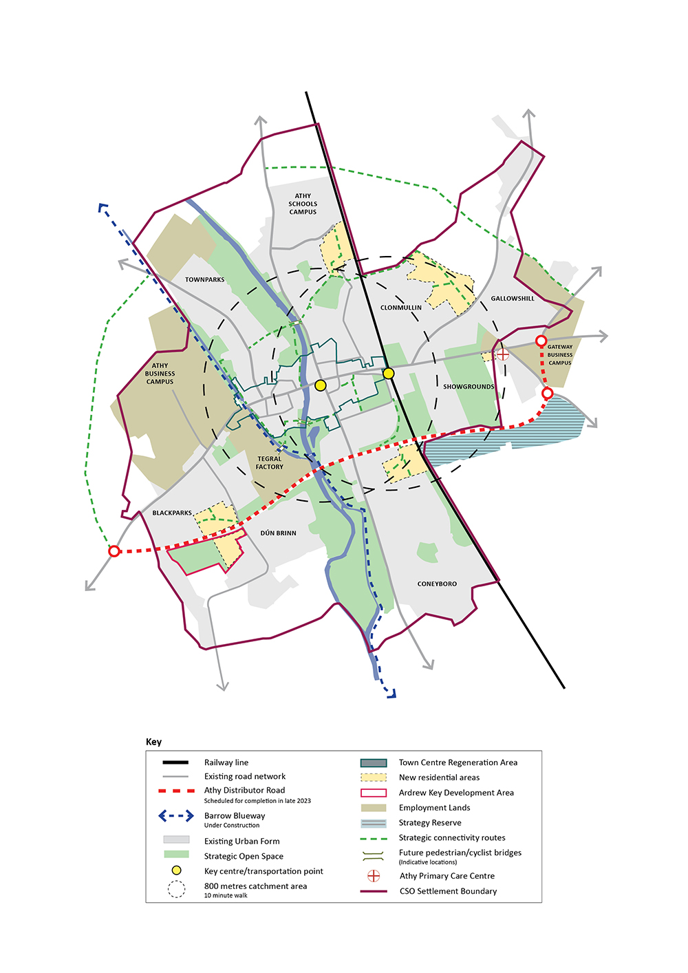
In the post-2027 period and following the building out of identified sites, it is considered that the lands situated to the southeast of the town, adjacent to the future Athy Distributor Road, represent the most appropriate area to cater for future strategic requirements to accommodate the orderly and sequential expansion of the town, at a location which is proximate to public transport at the train station, and with suitable access to other services such as the Primary Care Centre, as illustrated in Figure 3.2 (Athy Development Strategy map). For this reason, these lands have been zoned as ‘Strategic Reserve’, a designation that seeks to protect such lands from inappropriate forms of development which would impede the orderly and efficient expansion of the urban settlement.
|
Policy CS1 – Core Strategy CS1 It is the policy of the Council to support the sustainable long term growth of Athy in accordance with the Core Strategy of the Kildare County Development Plan 2017-2023 (or any succeeding plan), the provisions of the National Planning Framework and the Regional Spatial and Economic Strategy 2019-2031. Objectives It is an objective of the Council to: CSO1.1 Support and facilitate compact growth through the sustainable intensification and consolidation of the town centre and established residential areas. CSO1.2 Monitor the scale, type, tenure and location of constructed and permitted developments in Athy during the lifetime of the Plan and apply appropriate development management standards to ensure compliance with the Core Strategy to achieve the delivery of strategic plan-led and coordinated balanced development within the town. CSO1.3 Prioritise the development of sites zoned A: Town Centre and C: New Residential within the town as set out in Chapters 2, 4 and 11 and Appendix 1 of this Plan. CSO1.4 Support and facilitate the implementation of the Urban Regeneration Framework for the town as set out in Appendix 1 of the Plan. CSO1.5 Focus new enterprise development into lands identified for Industry and Warehousing and Enterprise and Employment uses. CSO1.6 Support new residential development and infill development that occurs in tandem with the delivery of supporting physical and social infrastructure. CSO1.7 Preserve the lands identified as ‘Strategic Reserve’ on Map 6: Land Use Zoning Objectives, thereby controlling the level of piecemeal and haphazard development on these lands and safeguarding their strategic value in accommodating the orderly sequential expansion of the urban settlement beyond the current Plan period. |
Figure 3.2: Athy Development Strategy Map
- 2- The figure 9,677 comprises of the population living within the settlement boundary of Athy as defined by the CSO (see Map 6: Land Use Zoning Objectives) and based on the results of Census 2016 and not the population of the larger Athy Legal Town area which was abolished under the Local Government Reform Act 2014.
- 3- The CSO settlement boundary transects a site zoned C: New Residential on the Dublin Road (see Map 4: Land Use Zoning Map). All other new residential and town centre sites are located within the CSO settlement boundary.
- 4- Source: Central Statistics Office (CSO) and the All Ireland Research Observatory (AIRO).
- 5- It is further noted that all of County Kildare was designated a Rent Pressure Zone in September 2020.
- 6- Note: 765 cases equate to housing units not persons. This figure has been provided by the Housing Section of Kildare County Council (July 2020).
Clár ábhair
Tuarascálacha
Tuairimí
Tuairimí
Additional 'New Residential' Zoned Lands Required
This submission relates to a c.7ha landholding which is currently located within the town boundary and is zoned for 'new residential' and 'open space' uses. Given the requirement for...
Retention of zoning for existing residential and infill
See attached Submission
Request to rezone Prusselstown old Pitch & Putt course (R14 NV99) to new residential for group housing on serviceable sites
Senior Executive Planner,
Athy LAP Submission,
Planning Department,
Kildare County Council,
Devoy Park,
Naas, W91 X77F
Re:...
TII Submission to Draft Athy LAP
TII submission attached under Chapter 3