Chapter 7 of the Athy Local Area Plan covers the county’s sustainable transport strategy. GNI welcomes the Councils aim to “To promote and develop a sustainable transport network for Athy.’ ...
07. Movement & Transport
Dúnta17 Nol, 2020, 07:00 - 8 Fea, 2021, 17:00
Aims:
- To promote and develop a sustainable transport network for Athy that improves access to walking, cycling and public transport while also providing an appropriate level of road infrastructure and traffic management to support future development;
- To facilitate the development of a universally accessible and integrated network of pedestrian and cycle routes, linking identified key destinations in Athy, thus providing for a realistic and convenient alternative to the car for short journeys within the town.
7.1 Overview
Policy documents at all levels of the spatial hierarchy recognise that current transport and travel patterns are unsustainable and are having a negative effect on the quality of life in our urban environments. Smarter Travel, the Government’s Transport Policy for Ireland (2009-2020) has sought to disrupt the ‘business as usual’ trend in which the private vehicle predominates and initiate a shift to public transport and other sustainable forms of travel. In this regard, the National Planning Framework (2018) supports the development sustainable movement in Ireland and includes a National Planning Objective (NPO 27) which seeks to ensure the integration of safe and convenient alternatives to the car into the design of our local communities. The Transport Strategy for the Greater Dublin Area 2016-2035, which includes Athy, also seeks the incorporation of sustainable land use and transport planning policies across the GDA. Such sustainable movement policy provisions are further outlined in the Regional Spatial and Economic Strategy (RSES) and in the Kildare County Development Plan.
7.1.1 Movement and Transport in Athy
Despite the adoption of sustainable movement policies over the past two decades or more, the much-desired modal shift away from private transport has not occurred. Whilst this situation is not unique to the town, both the Area Based Transport Assessment (see Section 7.3) and the Urban Regeneration Framework (Appendix 1) note the dominance of the private vehicle within Athy. This is due to the unconnected pattern of development within the town, particularly within residential estates, the peripheral location of some key destinations, and the lack of supporting transport infrastructure to encourage the development of sustainable movement patterns.
Section 2.3 of the Urban Regeneration Framework (see Appendix 1) illustrates the extremely limited areas of the town which are reachable with a 10-minute walking distance of both the schools campus (Monasterevin Road) and the recently opened Athy Primary Care Centre (Dublin Road). It is therefore unsurprising that Census 2016 recorded only 17% of workers in the town travel to their place of work by sustainable modes (walking, cycling, public transport) and almost half (48%) of the pupils and students travel to school/college by car. Whilst the current situation appears to be entrenched, there are a number of opportunities which have the ability to provide for the realisation of a more sustainable transport model. Such initiatives include the Athy Distributor Road, which will reduce through traffic in the town by c. 40-50%, thus freeing up space for alternative modes of movement, and the Barrow Blueway which will provide for a high quality off-road pedestrian and cycling route through the heart of Athy.
7.2 Area Based Transport Assessment (ABTA)
As part of the preparation of the Local Area Plan, an Area Based Transport Assessment (ABTA) was also undertaken. This supporting document (published alongside the Plan) has assisted in placing sustainable transport considerations to the forefront of land use planning decisions in the formulation of the Local Area Plan. The ABTA was informed by the vision statement and the 8 strategic development principles outlined in Section 2.3 of the Plan.
The ABTA examined the existing and proposed transport infrastructure and service provision across all modes of transport, including active modes (walking and cycling) in the town. The assessment provides an insight into the existing transport patterns and constraints in Athy and also identifies the interventions that are required to effectively accommodate the anticipated increase in demand due to planned population growth, ensure the optimal transportation interventions can be planned, and drive a shift towards sustainable movement.
The outputs of the ABTA include a series of proposed options and measures to improve the transport network of the town and have informed the contents and policy objectives of this Chapter. These proposals also include measures designed to ensure the integration of areas designated for new residential development in the town, with particular reference to developing active and sustainable modes of travel (see Section 11.3 Phasing and Infrastructure Delivery Schedule).
7.3 Planning for Sustainable Movement in Athy
The achievement of a comprehensive and meaningful transition towards a model of sustainable movement in Athy is perhaps one of the most critical components needed to realise the future vision for the town, as outlined in Section 2.3. This is primarily because the creation of sustainable integrated communities (one of the 8 strategic development principles) can only be achieved by providing residents with a realistic and convenient alternative to the private car which links all key destinations in the town.
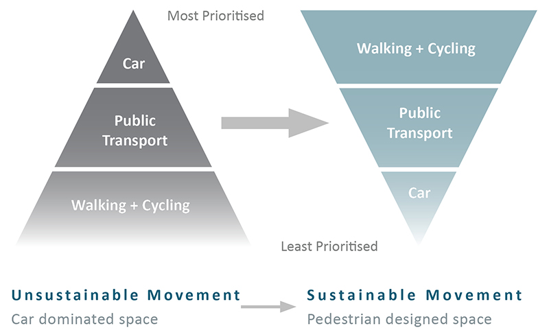
Figure 7.1: Existing and Desired Movement Hierarchies
Furthermore, without the delivery of sustainable movement within in the town, other strategic development principles such as the successful regeneration of the town centre and the development of an age friendly community cannot be achieved. Accordingly, this Plan will seek to maximise the opportunities arising from the Athy Distributor Road (currently under construction), capitalising on the additional space available in the town centre to create a transformed public realm, and expanding the high-quality pedestrian and cycling links formed by both the Distributor Road and the Barrow Blueway (currently under construction) to link all key destinations within the town.
7.4 Active Transport Modes - Walking and Cycling
Providing the infrastructure to promote and facilitate active modes of transport within the town forms a key output of the ABTA. Sections 7.4.1 and 7.4.2 (see below) detail the specific measures proposed to develop the walking and cycling infrastructure of the town respectively. Together, these proposed measures combine to form a Connectivity Programme for Athy, which is listed as Priority Project 5 of the Athy Urban Regeneration Framework (see Section 3.6, Appendix 1).
It is envisaged that the Connectivity Programme will be implemented through collaboration between Kildare County Council, local communities, and educational bodies (local schools) to enable all stakeholders to work together towards the delivery a high quality, comprehensive and safe walking infrastructure and to promote walking and cycling in the town. The various measures proposed will be subject to a separate public consultation process as part of the overall consent procedure. The Council will continue to implement improvements to its pedestrian and cyclist infrastructure through its operations programme as resources become available prioritising locations where pedestrian activities are the greatest or most vulnerable.
It is noted that the connectivity programme proposes the construction of two new pedestrian/cycle bridges over the River Barrow comprising of; one to the south of the town centre, linking the Dominican Lands to the Abbey site; and one to the north of the K-Leisure facility connecting with Monasterevin Road.
7.4.1 Walking
The ABTA contains a series of proposals to provide an integrated walking network for Athy, with an emphasis on improving safety and increasing the walking mode share, particularly to schools. This can be achieved by improving existing walking infrastructure and by creating new connectivity links, thereby increasing the catchment areas of key trip attractors in the town.
Another key feature of the ABTA is to integrate the Barrow Blueway into the pedestrian infrastructure of the town and provide a high-quality link between it and the town centre and the railway station.
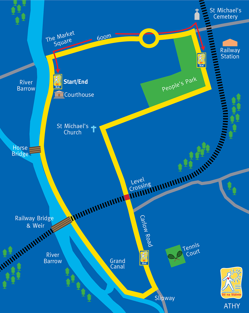
Additionally, the ABTA contains proposals to enhance and upgrade pedestrian infrastructure along other waterways within the town, thereby creating an integrated network of attractive greenways. Such routes will incorporate the Athy Slí Na Sláinte (see Figure 7.2) and also have the potential to form the basis of other signposted Heritage/Tourist Trails and looped walks. The provision of such amenity infrastructure has also been identified in Section 6.5.4 Tourism Development Opportunities.
Figure 7.2: Athy Slí Na Sláinte Route
The ABTA proposes a list of options which have been grouped into the following categories:
- Upgrading of existing infrastructure;
- Construction of new infrastructure, and;
- Supporting measures
Collectively, the proposed measures will provide for an integrated walking network in Athy and have a positive impact. Table 7.1 (see below) details the walking and connectivity options for the town and should be read in conjunction with Map 1.1 Walking and Connectivity Measures.
|
The following time used to define the implementation period for each measure:
These timescales are indicative only and will be subject to funding and resource availability. |
Table 7.1: Walking and Connectivity Measures
|
A: Walking and Connectivity Measures – Upgrading of Existing Infrastructure |
|||
|
Walking and Connectivity Measures (see Map 1.1) |
Description |
Timeframe |
|
|
WE1 |
The Barrow Blueway is proposed to consist of the development of a multi-use shared leisure route on the existing navigation towpath, which is a National Waymarked Route. This will include tailored surface finishes, information, directional, and safety signage, and all other associated ancillary works. The Blueway will cater for both pedestrians and cyclists and the section to Athy is due for completion by end of Q1 2022. |
ST/MT |
|
|
WE2 |
Improve link along the eastern side of the River Barrow from Barrow Quay to link with the Barrow Blueway at Horse Bridge. This will require upgrades to the existing bridge along this route |
MT/LT |
|
|
WE3 |
Improve link along western side of River Barrow, from N78, north to new pedestrian/cyclist bridge WN6 |
MT |
|
|
WE4 |
Improve link along eastern side of Grand Canal, from N78, north to St. Dominic’s Park |
MT |
|
|
WE5 |
Improve link along eastern side of Grand Canal, from N78, south to new pedestrian bridge (part of Barrow Blueway) |
MT |
|
|
WE6 |
Upgrade and improve pathway between St. John’s Lane and Greenhills |
MT |
|
|
Not on map |
Footpath surfacing improvements as determined by the upcoming N78 upgrade project through Athy Town Centre (removal of street clutter, footpath improvements, etc.) |
ST |
|
|
Not on map |
Conduct a survey to highlight the defective footpaths and design a priority list for repair works in conjunction with the relevant stakeholders. |
ST |
|
B: Walking / Connecting Options – New Infrastructure |
|||
|
Option |
Description |
Type |
Timeframe |
|
Not on Map |
North-western Distributor Road Note: This is not on shown on Map 1.1 as it is a long- term objective beyond the life of the Athy Local Area Plan 2021-2027. |
New Road |
LT |
| Not on map |
North-eastern Distributor Road
(Extended slightly south onto R417 to end of existing footpath on that road, as assume connecting footpath would be provided in conjunction with WN2 construction.) |
New Road | LT |
| WN3 | Athy Distributor Road (plus associated links, including link to train station) | New Road | ST |
| WN4 | New Street | New Road | LT |
| WN5 | Bridge over the River Barrow at Athy Library | Pedestrian / Cyclist Bridge | MT |
| WN6 |
Bridge over the River Barrow at Barrack Lane / Woodstock Castle to Stanhope Street / R417 |
Pedestrian / Cyclist Bridge | MT |
| WN7 |
Boardwalk along Cromaboo Bridge It is an objective of this ABTA to carry out a feasibility study regarding the provision of a boardwalk along Cromaboo Bridge. The scope of this study must have regard to the design and impact of the proposed boardwalk, having regard to the protected structure status of the bridge; it’s location within the ACA and the SAC status of the River Barrow and the associated requirements of the Habitats Directive. Currently this bridge is very narrow and heavily trafficked. During a recent walkability audit of the town centre, participants found the slope and narrowness of the footpaths very difficult to negotiate. The bridge was noted as one of the biggest limitations on the walkability of Athy. |
Boardwalk | LT |
| WN8 | Coney Green - Glebelands | New Link | MT |
| WN9 | Chanterlands – New residential lands. As part of new development | New Residential Lands Link | Timeline dependent on when lands are developed |
| WN10 |
Kingsgrove – New residential lands and link to ADR via section of Aughaboura Rd. |
New Residential Lands Link | Timeline dependent on when lands are developed |
| WN11 | Mansfield Grove – Athy Distributor Road footpath / cycleway | New Link | MT |
| WN12 |
New residential lands site at Ardrew, including links to:
Athy Distributor Road |
New Residential Lands Link | Timeline dependent on when lands are developed |
| WN13 |
Moneen Lane – New residential lands. |
New Link | MT |
| WN14 | New residential lands - Geraldine Road. As part of new development | New Residential Lands Link | Timeline dependent on when lands are developed |
| WN15 | New residential lands – Hollands Close, as part of new development | New Residential Lands Link | Timeline dependent on when lands are developed |
| WN16 |
Rheban Avenue and Moneen View - Moneen River. |
New Link | MT |
| WN17 | Hollands Park - Moneen View (currently an informal path) | New Link | ST |
| WN18 |
Moneen Lane - Stanhope Street, with offshoot into school. Links to bridge (WN6) |
New Link | MT |
| WN19 | WN20 - Ard Bhearú and White Castle Lawn. Connectivity links within new residential area. As part of new development. | New Residential Lands Link | Timeline dependent on when lands are developed |
| WN20 | Links into Schools Campus from residential estate to the south | New Link | MT |
| WN21 | Tonlegee Lawns and Branswood – Athy Distributor Road / Fortbarrington Road Junction. As part of new development | New Residential Lands Link | Timeline dependent on when lands are developed |
| WN22 | New link as part of Dominican lands indicative framework. Links new bridge WN5 – Convent Lane | New Link | Timeline dependent on when lands are developed |
| WN23 | Janeville to new bridge WN5 | New Link | ST |
| WN24 | Link in Dominican Lands from new bridge WN5 to Barrow Blueway | ||
| WN25 | Link to People’s Park from New Street (WN4) – As part of indicative framework for site to rear of Leinster Street | New Link | Timeline dependent on when lands are developed |
| WN26 | R418 Dublin Road (Texaco Station) to Clanard Court Hotel (including section along Gallow Hill Ct) | New Link | ST |
| WN27 | Barrow Blueway to Woodstock Industrial Estate | New Link | MT |
| C: Walking / Connecting Options – New Infrastructure | |||
|
Option |
Description |
Timeframe |
|
|
WS1 |
Increase priority for pedestrians at signalised junctions in Athy. Note: Not shown on Map. |
ST |
|
|
WS2 |
Provide pedestrian crossings at locations as determined by the upcoming N78 upgrade project through Athy town centre. Note: Not shown on Map. |
ST |
|
7.4.2 Cycling
The ABTA notes that there are currently no dedicated cycle lanes in Athy. In terms of other supporting infrastructure such as cycle parking facilities, there are some cycle stands provided at the train station, the schools campus and the primary care centre. However, no cycle stands in the town centre are noted.
The Greater Dublin Area Cycle Network Plan (2023) sets out the National Transport Authority’s plan for a cycle network throughout the Greater Dublin Area, comprising of an Urban Network, Inter- Urban Network and Green Route Network for the seven Local Authority areas in the GDA. The Cycle
Network Plan aims to ensure that cycling as a transport mode is supported and enhanced in order to achieve strategic objectives and reach national goals for cycle usage.
|
The Athy cycling routes identified within the Plan are: A1 N78 – Dublin Road to Kilkenny Road A2 River Barrow Greenway – Eastbank (Alternative to R417 Kildare Road) A3 Barrow Canal Greenway (Alternative to R428 Stradbally Road) N10 Barrow Canal Greenway, West of Robertstown to Athy K20 Newbridge - Curragh - Suncroft – Athy - A number of other Urban Town Network routes around Athy |
The Barrow Blueway and Athy Distributor Road, which are both currently under construction, will provide for dedicated cycle tracks. Similar to the walking network, the ABTA notes that these two schemes will provide two major cycling spines east-west and north-south. However, additional cycling infrastructure will be required to link residential areas with key trip attractors around the town, particularly to schools. The objective of this ABTA regarding cycling is to provide an integrated network for Athy and improve safety for cyclists, with a focus on improving the cycling mode share, particularly to schools.
The cycling options are divided into infrastructure measures and supporting measures. The type of cycle track to be provided (cycle track, shared street, greenway, etc.) is indicated beside each option. Exact details of the cycle option, for example, if it is segregated or on-road would be examined at detailed design stage.
|
The following time used to define the implementation period for each measure:
These timescales are indicative only and will be subject to funding and resource availability. |
Table 7.2 (see below) details the cycling measures for the town and should be read in conjunction with Map 1.2 Cycling Measures.
Table 7.2: Cycling Measures
|
A: New/Upgraded Infrastructure |
|||
|
Cycling Measures (see Map 1.2) |
Description |
Type |
Timeframe |
|
Not on Map |
North-western Distributor Road Note: This is not on shown on Map 1.2 as it is a long- term objective beyond the life of the Athy Local Area Plan 2021-2027. |
New Road |
LT |
|
Not on Map |
North-eastern Distributor Road Note: This is not on shown on map as it is a long- term objective beyond the life of the Athy Local Area Plan 2021-2027. |
New Road |
LT |
|
CL3 |
Athy Distributor Road |
New Road |
ST |
|
CL4 |
New Street |
New Road |
LT |
|
CL5 |
Barrow Blueway |
Blueway |
ST/MT |
|
CL6 |
Bridge over the River Barrow at Athy Library |
Pedestrian / Cyclist Bridge |
MT |
|
CL7 |
Bridge over the River Barrow at Barrack Lane / Woodstock Castle to Stanhope Street / R417 |
Pedestrian/ Cyclist Bridge |
MT |
|
CL8 |
Improve link along the eastern side of the River Barrow from Barrow Quay to link with the Barrow Blueway at Horse Bridge. This will require upgrades to the existing bridge along this route and a suitable cycle path under or around Horse Bridge to make safe for cycling |
Greenway |
MT/LT |
|
CL9 |
Improve link along western side of River Barrow, from N78, north to new pedestrian / cyclist bridge CL7 |
Greenway |
MT |
|
CL10 |
Improve link along eastern side of Grand Canal, from N78, north to St. Dominic’s Park |
Greenway |
MT |
|
CL11 |
Improve link along eastern side of Grand Canal, from N78, south to new pedestrian bridge (part of Barrow Blueway) |
Greenway |
MT |
|
CL12 |
Geraldine Road |
Cycle track/ lane |
MT/LT |
|
CL13 |
Dublin Road R418 – From N78 Roundabout to junction with Gallows Hill Ct |
Cycle track/ lane |
LT |
|
CL14 |
N78 – From Roundabout with Dublin Road to Canal Bridge |
Cycle track/ lane |
ST |
|
CI15 |
R417 – Junction with N78 to junction with new pedestrian bridge over River Barrow (CI7) |
Cycle track/ lane |
MT |
|
CL16 |
R417 – From new pedestrian bridge over River Barrow (CL7) to Schools Campus |
Cycle track/ lane |
ST |
|
CL17 |
R417 – Schools Campus to junction with new North- eastern Distributor Road |
Cycle track/ lane |
LT |
|
CL18 |
Link between CL7 and CL10, via Barrack Lane, Green Hills, Woodstock Street and St. Dominic’s Park |
Cycle track/ lane |
ST |
|
CL19 |
Improve pathway between St. John’s Lane and Greenhills |
Cycle track/ lane |
MT |
|
CL20 |
N78 – From Canal Bridge to junction with Athy Distributor Road / North-western Distributor Road |
Cycle track/ lane |
LT |
|
CL21 |
Fortbarrington Road – From junction with Athy Distributor Road to N78 |
Cycle track/ lane |
MT |
|
CL22 |
R417 – From junction with Athy Distributor Road to N78 |
Cycle track/ lane |
MT |
|
CL23 |
Canal Side, Green Alley and Convent Lane and around Library to new pedestrian/cyclist bridge (CL16) – As part of Dominican lands indicative framework |
Cycle track/ lane |
Timeline dependent on when lands are developed |
|
CL24 |
New cycle link between Janeville and new pedestrian/cyclist bridge (CL16) |
Cycle track/ lane |
ST |
|
CL25 |
Link to People’s Park from New Street (CL4) – As part of indicative framework for site to rear of Leinster Street |
Cycle track/ lane |
Timeline dependent on when lands are developed |
| CL26 | Link between N78 and train station, via Church Road | Cycle track/ lane | MT |
| CL27 | Upgrade link between Barrow Blueway and R417 between Oak Lawn and Kingsgrove | Cycle track/ lane | MT |
|
B: Supporting Cycle Measures (not on map) |
|||
|
Option |
Description |
||
|
CS1 |
Provision of cycle parking at train station and bus interchange |
||
|
CS2 |
Provision of cycle parking at schools, healthcare centres and sports facilities |
||
|
Policy MT1 – Walking, Connectivity and CyclingMT1 It is the policy of the Council to promote enhanced connectivity for pedestrians and cyclists within Athy in order to improve access to the town centre, local schools, residential areas, recreational facilities, public transport services and other amenities. Objectives It shall be an objective of the Council to: MTO1.1 Support and promote the use of sustainable active transport modes in Athy and seek to implement a connected network of walking and cycling infrastructure in the town as detailed in Table 7.1 and 7.2 and illustrated on Map 1.1 and 1.2, in conjunction with the National Transport Authority, other statutory agencies, and the relevant stakeholders. The final design details shall be subject to appropriate environmental assessment, where applicable, and undergo a separate public consultation process. MTO1.2 Support the implementation of the actions contained in the Athy Walkability Audit (2020) and ensure that all footpaths in Athy are accessible to all members of the community, including people with disabilities, the elderly and people with young children. MTO1.3 Continue to work with Waterways Ireland to progress the completion of the Barrow Blueway route. MTO1.4 To work with the National Transport Authority (NTA) to implement the Greater Dublin Area Cycle Network Plan (2013) proposals for Athy, subject to detailed engineering design and any mitigation measures presented in the Strategic Environmental Assessment (SEA) and Natura Impact Statement (NIS) accompanying the NTA Plan. MTO1.5 Support the creation of new pedestrian and cycle links across the River Barrow that enhance connectivity in the area and link residential areas, the town centre, community facilities and public spaces/amenities as proposed under the Athy Area Based Transport Assessment. The final design details shall be subject to the appropriate environmental assessment and public consultation MTO1.6 Ensure that all development within Athy allows for connectivity (pedestrian, cyclist and vehicular) to adjacent lands in accordance with the National Transport Authority’s Permeability Best Practice Guide (2015), or any updated version of same. MTO1.7 Provide appropriate, secure and sheltered bicycle parking facilities subject to demand analysis, at appropriate locations at:
MTO1.8 Seek to improve and promote looped walks in conjunction with Slí na Sláinte and other relevant bodies recognising them as important health and recreation infrastructure within the town. |
|
Actions
|
7.5 The Public Realm
Section 2. 7 of the Urban Regeneration Framework (see Appendix 1) investigated the public realm in Athy and found it to be generally of poor quality. There are a number of elements that combine to create a problematic and hostile public realm for pedestrians, cyclists and more vulnerable road user, such as children, older people and people with disabilities. These issues which need to be addressed, include:
- The dominance of vehicular traffic in the town and the lack of supporting walking and cycling infrastructure (including the complete absence of cycle paths) to provide a realistic alternative to the private car.
- The level of congestion arising from trips to drop-off and collect children to/from schools in the town.
- Disconnected and substandard footpaths, particularly within the town centre.
- The location and extent of public car parking within the town centre resulting in an excess of hard and uninviting landscaping in streets and public spaces.
- The general unattractive nature of public space with poor/disjointed landscaping along with the haphazard and inconsistent use and placement of materials, street furniture and signage.
It is a specific objective of this LAP to commence the preparation of a Public Realm Strategy for Athy within 12 months of the adoption of this Plan (Objective UCRO1.10, Chapter 5). This Strategy will set out a programme of works to create an attractive and vibrant urban environment that is well connected and safe, and one which encourages people to use more sustainable forms of transport, particularly for short trips to key destinations within the town (refer to Section 5.2.1). It is envisaged that the Public Realm Strategy will have a transformative effect on the urban environment of Athy when implemented in conjunction with the recommendations of the ABTA, as outlined in Section 7.4.1 and Section 3.3 Enhancing Connectivity of the Urban Regeneration Framework (Appendix 1).
7.6 Car Parking
Car parking while a necessary feature of any town centre should not be allowed to dominate the public realm or compromise the experience of the pedestrian shopper. In this regard, the Urban Regeneration Framework (Appendix 1, Section 2.7.4) investigated the extent of the present public parking arrangements within the commercial core of Athy and found it to take up a considerable proportion to town centre. In several instances it was found that car parking was the dominating feature in a number of important civic spaces in the town, detracting from the historic character and setting of what is a designated Architectural Conservation Area (ACA). In view of this situation, the Urban Regeneration Framework proposes that a comprehensive car parking management plan would be undertaken as part of a Public Realm Strategy for the town (Objective UCRO1.10). The ABTA acknowledges this provision and supports the car parking management plan been developed under the auspices of the Public Realm Strategy. The management plan will seek to take a balanced approach to effectively manage parking to support the local economy and encourage sustainable travel modes in order to reduce reliance on the private car.
It is noted that the ABTA has outlined several measures regarding the provision of car parking in the town. These proposals are supported by an objective of the Plan.
|
Policy MT2 – Car Parking MT2 It is the policy of the Council to manage the provision of parking to provide for the needs of residents, business and visitors to Athy Town Centre.
Objectives MTO2.1 Apply the parking standards in the Kildare County Development Plan and relevant Section 28 Guidelines in considering applications for planning permission in Athy. MTO2.2 Support and facilitate the implementation of the preferred car parking management measures, as identified in the Athy Area Based Transport Assessment. MTO2.3 To make provisions for the use of electric vehicles through a significant increase in the provision of clearly and exclusively designated electric car charging points on public and private land in partnership with ESB and other relevant stakeholders and landowners. Action
|
7.7 Public Transport
The Area Base Transport Assessment has highlighted various deficiencies in the current public transport offering in the town. For example, although there are bus connections to a number of hinterlands, major towns and cities in the province (as well as Dublin Airport), these are limited in frequency, limiting their potential as viable transport modes for commuting journeys. In addition, although train services from Athy are spread relatively evenly across the day, there is no increased frequency at peak hours in the morning and evening. There are also no early morning trains towards Carlow, Kilkenny and Waterford.
Figure 7.2: Athy Slí Na Sláinte Route
Credit: Athy Photography
The ABTA proposes a number of measures to improve the existing public transport offering to encourage a shift to sustainable transport modes. Whilst this Local Area Plan includes objectives supporting the implementation of such proposals within the town, it notes that the provision of bus and rail services is outside of the remit of this Plan.
|
Policy MT3 – Public Transport MT3 It is the policy of the Council to promote the sustainable development of Athy by supporting and guiding the relevant national agencies in their remit to deliver improvements to the public transport network and to public transport services. Objectives It shall be an objective of the Council to: MTO3.1 Focus people-intensive land uses around existing and planned public transport nodes and improve access to services. MTO3.2 Support and facilitate the delivery of the preferred public transport (bus and rail) enhancements in the town, as identified in the Athy Area Based Transport Assessment. MTO3.3 Engage with the National Transport Authority (NTA), Dublin Bus, Irish Rail, Local Link and other stakeholders to improve the provision of public transport in Athy including the provision of a new bus interchange, close to the train station and the extension of certain bus routes to access this interchange. MTO3.4 Support improving the quality and extent of the bus infrastructure within the town including the provision pull-in bays, bus shelters, seating and real time passenger information. MTO3.5 To facilitate the provision of taxi and hackney services and appropriately located taxi parking in Athy. Action
|
7.8 Roads and Streets Network
The Athy Distributor Road (scheduled for completion in late 2023) will provide a new east-west link to the south of the Duke Street – Leinster Street axis, bypassing the congested N78. This new road will provide Athy with a high-quality route for active travel modes and connects directly to the train station via a pedestrian/cyclist spur from the road.
On completion of the Distributor Road Scheme, it is envisioned that the reduction in traffic along the N78, resulting from the Athy Distributor Road and the potential modal shift to active travel modes from walking and cycling measures (removing some car based internal trips) will result in a significantly less congested main street. This will result in safety improvements, particularly for vulnerable road users and allow for a general upgrade of the public realm. However, there are two regional roads converging on Athy from the north (R428 to Stradbally and R417 north to Monasterevin) which will not be able to bypass the town centre via the new distributor road. As such, there will still be a level of regional through traffic along the main street. To address this issue the ABTA proposes that two new routes be constructed, as follows:
- North-western Distributor Road – linking the western end of the Athy Distributor Road (N78 Ballylynan Road) to the R428 Stradbally Road.
- North-eastern Distributor Road – linking R417 to Monasterevin with the R418 to Kilcullen
Whilst the Plan acknowledges that the purpose of these proposed routes is in keeping with one of the key objectives of the ABTA i.e. to reduce unnecessary vehicular trips through Athy Town Centre and identify mitigation measures to improve road safety and minimise collision hotspots, it also notes that the construction of these routes are a long term proposition, beyond the life of the Plan.
Consequently, the routes are not illustrated on the Transport and Movement Maps, nor are they specifically supported by any objective of the Local Area Plan.
The ABTA identifies a number of other measures to improve the roads and streets network in the town and these are supported by objectives of the Plan.
7.8.1 New Street
The ABTA proposes the creation of a new street in Athy Town Centre. This new route will link Leinster Street to Back Square. Whilst this proposal has seen different iterations in past statutory plans for the town, it should be noted that its purpose is to function as an urban street and not as an inner relief road in the town.
New Street will contribute fundamentally to the connectivity of the town and allow for significant improvements to be made along the main street, catering for pedestrians, cyclists, and vehicular traffic appropriately. This will be achieved by making the section of Leinster Street parallel to New Street one-way from west to east, opening up road space for active travel modes and an enhanced public realm. In turn, New Street will run one-way from east to west, allowing for the integration of appropriate pedestrian and cyclist infrastructure (see Map 1.3 Roads and Streets Network).
|
Policy MT4 – Road and Street Network MT4 It is the policy of the Council to maintain, improve and extend the local road network in and around Athy to ensure a high standard of connectivity and safety for all road users. Objectives It shall be an objective of the Council to: MTO4.1 Maintain and improve, as required, the local road network to ensure a high standard of road quality and safety in accordance with the requirements of the relevant legislation. MTO4.2 To support and facilitate the continued development and completion of the Athy Distributor Road. MTO4.3 To support and facilitate the development of ‘New Street’ as identified in the Athy Area Based Transport Assessment and illustrated on Map 1.3 Roads and Streets Network Measures. MTO4.4 Support the implementation of the recommendations of the Athy Area Based Transport Assessment regarding the road and street network of the town. MTO4.5 Co-operate and liaise with the Department of Transport, the National Transport Authority (NTA) and Transport Infrastructure Ireland (TII) in relation to securing appropriate improvements/extensions to the transport network within Athy. MTO4.6 Ensure that development proposals within Athy Town Centre are subject to a Traffic Impact Assessment (TIA), to be carried out in accordance with the Traffic and Transport Assessment Guidelines (2014). The requirement for all other developments will be determined on a case-by-case basis. MTO4.7 Ensure that any significant new development takes place in proximity to public transport routes and can be adequately served by the road network. MTO4.8 Provide for traffic calming and speed reduction measures throughout the town, where necessary as funding allows, and ensure that all new developments are designed to incorporate appropriate traffic calming measures as set out in the Design Manual for Urban Roads and Streets. |
|
MTO4.9 Reduce the harmful effects of traffic noise by ensuring noise mitigation measures are implemented into new developments in proximity to national routes, regional routes and significant urban streets. Developers shall engage a suitably qualified acoustic specialist to prepare an Acoustic Design Statement for all new developments with the potential to impact sensitive noise receptors from traffic noise. The Statement shall have regard to the thresholds set out in the Kildare Noise Action Plan 2019-2023 (or any subsequent plan). Action
|
Clár ábhair
Tuarascálacha
Tuairimí
Tuairimí
Proposed works objective - Footpath link from Clanard Court Hotel to Athy Town
We wish to make a case for extending the footpath from Conlans Centra to The Clanard Court Hotel to promote guest safety and comfort and ensure that our many tourists visiting Athy and residing with...
movement and strategy
07. Movement & Transport
That this council explore the removal of HGV Vehicles at schools at certain times.
That this development explores the development of a...
Against of proposal WN19 and WN20 routes.
We've been living in our home in this estate for over a decade, it is a calm and child friendly, I believe that if the routes WN19 & WN20 it will make it unsafe for the children to play and bring...
Objection to connectivity links WN19 & WN20
We've bought our family home in Cois Bhearú in 2017. At the time the house costed us €20k more, than a similar house in other parts of Athy. Cois Bhearú have appealed to us...