Submission to Draft Athy Local Area Plan 2021-27
On behalf of the Executive Committee of Athy Rugby Football Club
Concerning lands at Gallowshill, between The Showgrounds and Shanrath...
09. Natural Heritage, Green Infrastucture & Strategic OpenSpace
Closed17 Dec, 2020, 07:00 - 8 Feb, 2021, 17:00
Aims:
-
To protect, enhance, create and connect natural heritage, high-quality amenity areas and other green spaces throughout Athy for both biodiversity and recreational use and to ensure that the future development of the town complements its natural setting;
-
To ensure that the natural heritage and green infrastructure of Athy is allowed to play an enhanced role in strengthening the climate resilience of the town.
9.1 Overview
The concept of biodiversity goes beyond identifying the variety of species that may occur within a given area. Rather, it recognises the inter-connectivity and interdependencies that occur between different species and their habitats. For example, a negative impact in the local environment could adversely affect a much wider ecosystem. Many ecosystem services are provided by biodiversity such as pollution control, flood mitigation, carbon sequestration and sustaining agricultural production. The conservation and enhancement of biodiversity and natural heritage is therefore an integral part of good environmental management and sustainable development.
|
What is Biodiversity? Biological diversity or biodiversity as it is more commonly known, refers to the variety of all living things, including plants, animals and their habitats as well as the physical and geological foundation that forms the landscape. The idea of biodiversity is a well-established feature of nature; however, the term was previously more often referred to as ‘flora and fauna’. |
There is a great diversity of natural and semi-natural habitats in Athy, ranging from its hedgerows to groups of trees, grassland areas, and riparian habitats along its river and canal corridors. It is considered that the natural heritage of Athy, while somewhat underutilised, is a critical asset for the town which, when taken in combination with its built heritage, has huge potential, if appropriately and sensitively developed, to improving the overall wellbeing and quality of life of the town’s residents whilst also providing critical economic and tourism opportunities.
The natural environment also plays a vital role in helping communities adapt to and mitigate the negative effects of climate change. Accordingly, the policies and objectives set out in the Plan seek to protect Athy’s existing habitats and promote the sensitive incorporation of new green infrastructure features into the existing urban fabric of the town alongside new developments, in order to foster greater biodiversity, whilst also utilising such green infrastructure for climate mitigation purposes.
9.2 Designated Sites
Athy boasts two significant designated sites which contribute greatly to its character. The River Barrow is listed as a Special Area of Conservation (SAC) and the Grand Canal is designated as a proposed Natural Heritage Area (pNHA).
Special Areas of Conservation (SACs) are legally protected under the EU Habitats Directive (92/43/EEC) and are selected for the conservation of Annex I habitats and Annex II species. The River Barrow flows southwards through the town and forms part of the River Barrow and River Nore SAC (Site code: 002162). The site is of considerable conservation significance given the occurrence of good examples of habitats and of populations of plant and animal species that are listed in Annexes I and II of the E.U. Habitats Directive respectively. Furthermore, the River Barrow is of high conservation value for the populations of bird species that use it.
The Barrow Line of the Grand Canal is a man-made waterway linking the River Liffey in Dublin with the Shannon at Shannon Harbour and the Barrow at Athy. The Grand Canal system is protected under national legislation by way of its designation as a proposed Natural Heritage Area (pNHA) – (Site Code: 02104). It runs through the town and intersects with the River Barrow 500 metres south of Cromaboo Bridge.
The Grand Canal pNHA comprises the canal channel and the banks on either side of it. The canal supports important habitats such as hedgerows, tall herbs, calcareous grassland, reef fringe, open water, scrub and woodland. Diverse ranges of species use the site including the Annex II species such as otter and white-clawed crayfish. The ecological value of the canal lies more in the diversity of species it supports along its linear habitats than in the presence of rare species. Associated canal structures and buildings also contribute to the setting and historic character of the canal.
The River Barrow and the Grand Canal have the potential to play a key role in the regeneration of the town. This Local Area Plan aims to realise the full potential of these waterbodies as local and national amenities by providing supporting policies and objectives which seek to enhance walking/cycling route options connecting with residential areas and other public open spaces in the town and further afield (including the Barrow Blueway project) without compromising the integrity of these designated sites.
|
Policy NH1 - Natural Heritage NH1 - It is the policy of the Council to support the protection of species and habitats that are designated under the Wildlife Acts 1976 and 2000, the Birds Directive 1979 and the Habitats Directive 1992 as well as areas of high local biodiversity value and to ensure that developments with potential to impact the integrity of the Natura 2000 network will be subject to Appropriate Assessment. Objectives It is an objective of the Council to: NH1.1 Protect, conserve and manage the River Barrow and River Nore SAC and contribute to the protection of the ecological, visual, recreational, environmental and amenity value of the Grand Canal pNHA. NH1.2 Ensure screening for Appropriate Assessment (AA), in accordance with Article 6(3) of the Habitats Directive is carried out with respect to any plan or project, including masterplans. NH1.3 Ensure that any proposal for development within or adjacent to the Grand Canal pNHA is located and designed to minimise its impact on the biodiversity, geological, water and landscape value of the pNHA. NH1.4 Ensure all applications for planning permission within or adjacent to the Grand Canal pNHA are accompanied by an Ecological Impact Assessment (EcIA) prepared by a suitably qualified professional. NH1.5 Identify, protect, conserve and enhance wherever possible, wildlife habitats and species of local importance, not otherwise protected by legislation. Such habitats would include woodland, river, canal, wetlands and grassland areas along with field boundaries (hedgerows, stone walls and ditches). These features form part of a network of habitats and corridors, which allow wildlife to exist and flourish and contribute to compliance with Article 10 of the Habitats Directive. NH1.6 Protect and conserve the integrity of soils that supports the rich biodiversity and ecological networks in Athy. Action
|
9.3 Green Infrastructure
The natural heritage features of Athy can be described as its green infrastructure network. This network supports native plant and animal species and provides corridors for their movement, maintains natural ecological processes and biodiversity, sustains air and water quality, protects from flooding and provides vital amenity and recreational spaces for communities. This Plan takes a proactive approach towards planning and managing the green infrastructure network of Athy by seeking to maximise the benefits of the multi-functionality that such natural heritage provides. In protecting and enhancing the green infrastructure network of the town important amenity and recreational spaces can be provided for communities, thereby contributing to the health and quality of life of residents and also allowing for increased climate resilience within the town in the years ahead.
|
What is Green Infrastructure? ‘Green Infrastructure’ is a term that is used to describe the interconnected network of environmental features such as nature conservation areas, parks, open space, rivers, floodplains, wetlands, woodlands and farmland and other open spaces that adjoin and are threaded through towns and villages. A green infrastructure network should be designed and managed as a multifunctional resource capable of delivering a wide range of environmental and quality of life benefits for local communities. |
It is important to note that not all pieces of green infrastructure perform the same functions and not all are of equal value. For example, a grassy strip between a footpath and the road surface provides a level of water regulation by providing a pollution control and a green space for excess water to soak into and it also provides a very limited habitat for plants and insects. Conversely, a riparian wetland would have a much greater capacity to absorb water, provide pollution control and would support a much greater range of biodiversity. To be effective, any project identifying Green Infrastructure must recognise these differences in value and distinguish what are the most important components.
9.3.1 Habitat Mapping
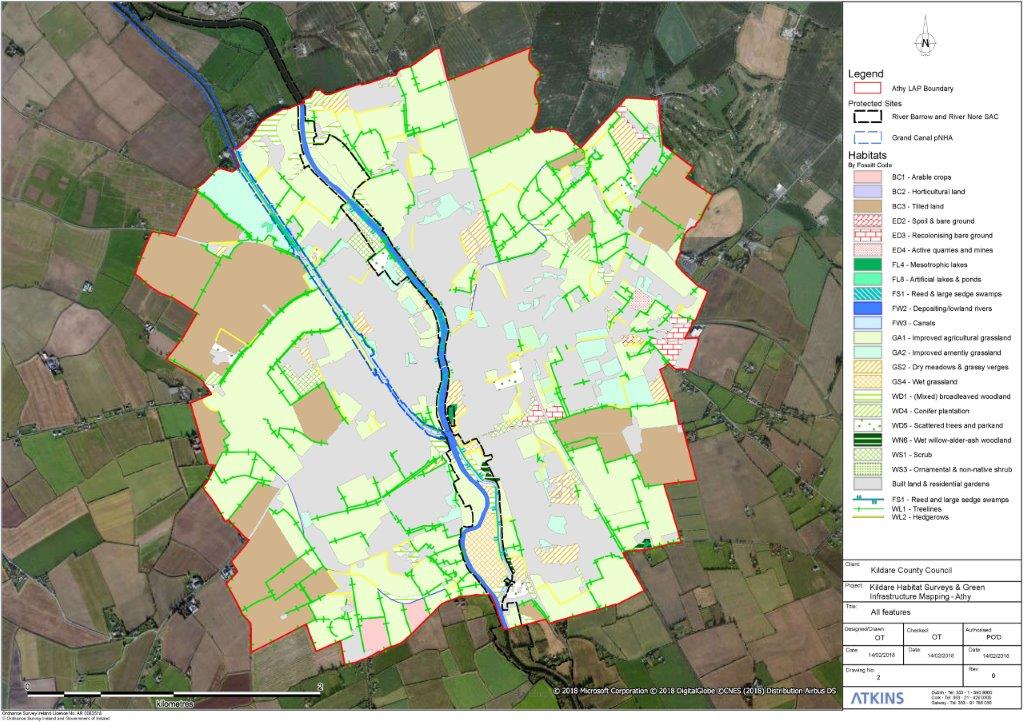
Under Article 10 of the EU Habitats Directive, planning and development policies must endeavour to conserve and sustainably manage corridors and stepping stone habitat features. As part of the preparation of this Plan, Kildare County Council commissioned a habitat mapping and green infrastructure survey for Athy in 201821. This report identified and mapped the various habitats and green infrastructure areas in the town. These maps are a valuable tool in the future planning of the area and also provide information for the general public and community groups.
The survey employed the Heritage Council’s habitat classification system and recorded habitats by features according to their ecological value (see Table 9.1). Map 9.1 provides detailed information of the location and distribution of the various habitat types listed below.
Table 9.1: Extent of habitats in Athy when grouped by ecological potential
| Broad Habitat Group | Heritage Council Habitat Types | Percentage |
|---|---|---|
|
Built and improved Grasslands |
|
90.1% |
|
Transitional |
|
5.1% |
|
Semi-natural |
|
4.8% |
Source: Habitat Survey and Mapping of Athy, 2018
As noted in Table 9.1 the dominant environment within Athy is categorised as being of low ecological value (i.e. built environment, improved agricultural grassland and amenity grassland). However, the habitat mapping has identified six main routes of green infrastructure (local biodiversity areas) in the town. These routes are named, as outlined below, with regard to their most noticeable features and all are connected to the largest and most important piece of green infrastructure and ecological corridor – the River Barrow. These routes are also considered to constitute ‘local biodiversity areas’ and form a critical component of the town’s Green Infrastructure. Map 4: Green Infrastructure illustrates key aspects of these areas which should be protected.
-
River Barrow: This local biodiversity area consists of the main river channel, bordering habitats, Ardreigh Island and section of the disused rail line west of the confluence of the River Barrow and Grand Canal. Notable habitats located within this area include; many small pockets of mixed
broadleaved woodland; long sections of reed swamp, the wetland/scrub mosaic north of Woodstock Castle ruins, significant amounts of dry meadows and grassy verges, “The Marina” mesotrophic lake, a number of semi-natural woodland areas within the study area, and the semi-natural wet grassland on Ardreigh Island. The eastern section of the Grand Canal is also contained within this area, as is the linear woodland and semi-natural grassland bordering the disused rail line going west. Many of these habitats are also contained within the River Barrow and River Nore SAC.
- Grand Canal: This area consists of the western section of the Grand Canal within Athy, as well as its fringe and bankside habitats, and other habitats to the west connected by the treeline and hedgerow network. This route also connects to the wider landscape to the north of the study area. Notable habitats include the Canal itself as well as its fringe and bankside habitats. The network of linear woodland and scrub links Cardington House Golf Course and Athy Business Campus to this route. There are significant amounts of scrub and dry meadows, grassy verges, hedgerows, and treelines within this infrastructure route.
- Bennetsbridge Stream: The Bennetsbridge Stream has been identified within this study as a local biodiversity area. This site comprises of Bennetsbridge Stream and small areas of wooded river valley. The adjoining hedgerow and treeline system link the site to small remnants of planted woodland at Tonlegee.
- The Rail line: The rail line green infrastructure route is focused to the south of Athy Railway Station. The habitats within this route are highly modified due to their proximity to an active rail line. However, the railway embankments provide a relatively contiguous corridor in the southeast of Athy which provides connectivity to the wider landscape. A key feature is a small area of semi-natural woodland and lake at Shanrath West; this is in private lands and managed by the Ballyroe Gun club as a nature reserve.
- Athy Stream and Prusselstown: This area is centred around the Athy Stream and adjoining habitats connected through the hedge network in the Prusseltown area. Athy Stream flows in a generally southwest direction before converging with the River Barrow within Athy town. While heavily altered in some sections, there is however a strong hedgerow network in the area of the Athy stream to the wider landscape. This route includes woodland and scrub areas in the region including that at Shamrock Lodge.
- Barrowford: Centred around Barrowford House and Demesne (outside the Plan boundary), this area includes many small sections of modified woodland which are interconnected through the hedge system in the area. The connectivity of this route to lands within the wider landscape is facilitated through its proximity to the River Barrow. The area has significant woodland directly adjacent to the River Barrow.
It is critical that these areas are safeguarded and given the opportunity to increase their extent and ecological function within the town by retaining links and supporting connectivity within the network. In addition, stepping stone habitats, including scattered trees and parkland as well as amenity areas within housing estates, further enhance the connectivity of habitats, and in turn, promote biodiversity across Athy.
Figure 9.1: Green Infrastructure Survey - All Habitat Features in Athy
|
Policy GI1 - Green Infrastructure GI1 It is the policy of the Council to protect, enhance and further develop the Green Infrastructure network in Athy to provide a shared space for amenity, recreation and biodiversity to thrive and to strengthen links to the wider regional network. Objectives It is an objective of the Council to: GI1.1 Reduce fragmentation of the existing Green Infrastructure network while protecting and enhancing its biodiversity by strengthening ecological links including stepping stone habitats (according to their value). GI1.2 Integrate new and existing Green Infrastructure as an essential component of all new developments and to restrict development that would fragment, damage or prejudice the integrity of the green infrastructure network. GI1.3 Ensure the key Green Infrastructure and habitat features identified in Map 4: Green Infrastructure, and the linkages they provide to larger areas of green infrastructure and the wider countryside are retained and integrated into the design of new developments as far as practicable. GI1.4 Seek that development proposals also include an outline of measures to protect the retained Green Infrastructure of a site during the period of construction. GI1.5 Provide for wildlife bridges (eco links) as part of any new pedestrian and cycle links across the River Barrow, the Barrow Line Canal and railway, thereby facilitating the free movement of people and species throughout the Plan area. GI1.6 Promote a network of pedestrian and cycle paths to enhance accessibility to the Green Infrastructure network, while ensuring that the design and operation of the routes responds to the ecological protection needs of each site. GI1.7 Maintain a biodiversity protection zone of 60 metres from the top bank of the River Barrow, 20 metres from the canal and not less than 10 metres from the top bank of smaller watercourses, with the full extent of the protection zone to be determined on a case by case basis by the Planning Authority, based on site specific characteristics and sensitivities. Strategic green routes and trails will be open for consideration within the biodiversity protection zone, subject to appropriate safeguards and assessments.22 GI1.8 Incorporate items of historical or heritage importance within the Green Infrastructure network as amenity features, where practical. GI1.9 Seek to protect trees with a particular local amenity or conservation value. GI1.10 Promote appropriate tree planting within the public realm with a particular focus on strategic open spaces as well as along transport networks. GI.1.11 Protect and enhance the existing character and setting along the route of the Barrow Blueway. Actions:
|
9.4 Strategic Open Space
Open spaces form a vital part of the urban environment. Such amenity spaces create benefits not only for the enhancement of the quality of life of residential areas but also provide opportunities for recreational activities, education and biodiversity through the preservation and enhancement of green infrastructure as well as helping to mitigate the impacts of climate change. The existence of quality open spaces also improves the visual attractiveness of places to live and work; it helps to create a sense of place and identity and can improve the economic performance of a town by attracting visitors and inward investment.
A Social Infrastructure Audit was carried out to inform the Local Area Plan and to examine the availability and capacity of existing social infrastructure facilities in Athy and future requirements and to make recommendations based on anticipated population growth. The Audit was structured and carried out in the following manner;
- Assessing the Existing Situation;
- Future Demand Analysis; and
- Social Infrastructure Recommendations.
The Existing Situation
There are 90.1 hectares of land zoned as ‘Open Space & Amenity’ within the plan area. These lands are used primarily for recreational and amenity purposes and represents 13.4% of the total area of the Plan.
Currently there is one Neighbourhood Park23, within the plan area (13.01 ha). This park comprises circa 19% of the total amenity open space provision in the study area. In addition to this neighbourhood park there is a local park (2 ha); green corridors (4.9 ha); sports areas (18.46 ha) and playgrounds (0.53 ha) with the remaining areas consisting of amenity green spaces and natural/semi-natural green spaces. The remaining spaces provide habitats for ecological purposes, a focal point for active and passive recreation, promote community interaction and help mitigate the impacts of climate change.
Future Demand Analysis
Using the UK’s Fields In Trust (FIT) recommended benchmark guidelines for ‘informal outdoor space’ it was determined that Athy would provide an acceptable amount of open space. Currently there are 21.96 hectares of sport and recreation area per 1,000 population which complies with the FIT benchmark guidance. While this would decrease during the course of the Plan to 1.61 ha per 1000 persons taking account of the projected increase in population, this figure would still comply with FIT standards.
The Kildare Open Space Strategy 201124 highlights that Athy currently has the full complement of public open space types and Athy currently exceeds this strategy’s recommended standard of 2 ha of open space per 1,000 persons. The population of Athy is envisaged to exceed 10,000 persons over the lifetime of this Local Area Plan. The open space Kildare Open Space Strategy 2011 therefore recommends two local parks are required ; one further local park is therefore proposed.
Furthermore, it was found that there is a significant shortage of play area facilities within the plan area. Play facilities, out-door gym equipment, benches and art installations should all be used to improve the quality of existing and proposed open spaces in Athy.
It was also noted there is currently a lack of sporting facilities in the western half of Athy. The proposed sports training hub (c. 5 ha) on Council owned lands at Ardrew is therefore welcomed. Whilst at an early stage of development it is envisaged the facility will be home to a range of active recreational activities and will have a number of training pitches.
Social Infrastructure Recommendations
There is an opportunity to enhance the green links between open spaces throughout Athy. These links vary in character from woodland and riverside/canalside walks to pathways within the urban context. These also have the potential to link historical points of interest. Many of the open spaces closer to the town centre and in the residential areas are also passive in nature. The introduction of amenities/facilities such as picnic tables, playgrounds or outdoor gym equipment should be considered and integrated into the existing open space network.
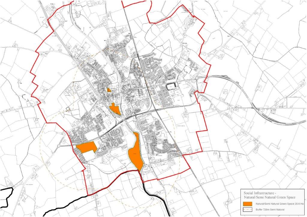
Amenity green space provision in Athy is over four times above FIT benchmark guidance. However, current playground provision is 0.055 per 1,000 people considerably short of the 0.25 FIT benchmark. Furthermore, it is noted the Kildare Open Space Strategy 2011 recommends that an additional 2-hectare local park in Athy with active uses is required once the population surpasses a population of 10,000 persons. These issues should be addressed within the lands identified as Natural / Semi-Natural Green Space in Figure 9.2.
Figure 9.2: Map of Natural /Semi-Natural Green Space
|
Policy OS1 Open Space OS1 It is the policy of the Council to provide for a hierarchy of high quality multi-functional public open spaces within Athy, and to preserve and protect such spaces through the appropriate zoning of lands. Objectives It is an objective of the Council to: OS1.1 Support the implementation of the proposed Open Space and Outdoor Recreation Strategy for County Kildare 2021 – 2031 with regards to its aims, recommendations and actions relating to the provision of open space and outdoor recreation infrastructure in Athy. OS1.2 Explore the feasibility of and develop and/or improve linkages and connections between the network of open spaces in Athy, without compromising the biodiversity along the banks of the River Barrow and banks of the Grand Canal. OS1.3 Continue to facilitate and promote community-managed gardens/allotments and green waste composting sites. OS1.4 Support and promote the development of a sports training hub (c. 5 ha) on Kildare County Council owned lands at Ardrew to cater for active recreation for residents. OS1.5 Support and facilitate the development of a new local eco-park (2 ha or larger in area) as part of the Dominican Lands Masterplan, which would provide active and passive recreation for residents, subject to appropriate environmental considerations. OS1.6 Cooperate with key stakeholders including landowners in the development (where appropriate) of universally accessible greenways and blueways, and other areas within Athy for recreational purposes, subject to appropriate environmental considerations. OS1.7 Promote and provide amenities and features such as playgrounds, outdoor gym equipment facilities and picnic tables in all open spaces to improve their quality and usability. OS1.8 Support the development and implementation of a masterplan for the Woodstock Lands surrounding Woodstock Castle within the lifetime of the Local Area Plan. |
21 The study area comprised of the now abolished Athy Legal Town area, approximately 1,053 hectares in size.
22. Any such green route or trail should be designed in accordance with the guidelines and principles outlined in ‘Planning for Watercourses in the Urban Environment’ (Inland Fisheries Ireland, 2020).
Contents
Observations
Observations
Natural Heritage , green infrastructure and strategic open space
09. Natural Heritage, Green Infrastructure & Strategic OpenSpace
The council look to develop more playing pitches and manage said pitches.
The council look to develop fishing...
New Playing Fields at Ardrew
Great news for Athy Hurling Club re the provision of new playing fields at Ardrew.
This new resource will be a marvellous community asset and give our members a great facility for training,...
Lands at St.Johns Lane, Athy, Co. Kildare
The attached submission makes a case for keeping the Town Centre zoning objective for the subject lands.
Inland Fisheries Ireland reply
Please see attached submission from Mr. Donnachadh Byrne, Inland Fisheries Ireland.