Litir Chumhdaigh
Dear Sir or Madam
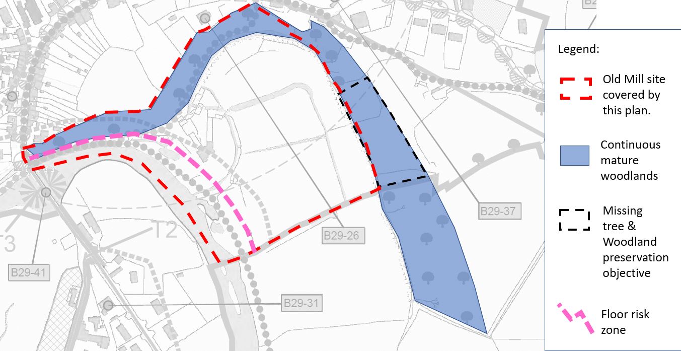
Referring to Map V2-3.4b, Ref: Ballymore Eustace Village Draft County Development Plan 2023 - 2029, I am writing in relation to survey and protect those trees deemed to be of sufficient amenity value.
Please see our observation and attached map.
Best regards
Ciara & Harvey Appelbe
On and in the vicinity of our site of the Old Woollen Mills in Ballymore Eustace there exists a substantial swath of mature woodland which we have made efforts to enhance and preserve for its ecological and amenity value.
We strongly support the objective to survey and protect these woodlands. Although we don't have the resources to complete comprehensive ecological surveys, it seems logical that the continuous and mature nature of the woodland adjoining the Liffey is valuable to a host of important species. Otter, pine martin, red squirrel, woodpecker, king fisher and deer have been observed in these locations.
We submit that the extent of the woodlands to be surveyed should form a contiguous block, as is the case on the ground, and should in the broader ecological context in light of the range of most species.
Include woodland areas missing from the objective
The important woodland ecology is likely to be a contiguous block taking in a larger area.
A flood risk zone is identified in Map V2-3.4b which covers parts of our site at the old mill in Ballymore Eustace. The boundary of this zone appears to have been drawn arbitrarily perhaps using hydrological modelling done at a much larger scale.
Our site adjoins the River Liffey at a point close to the Golden Falls dam, and therefore represents a managed water body. The risk of flooding only arises in the event of failure of the dam or management procedures, since there is no signficant catchment area to provide a source of flood water. This is beyond the scope of probaibilities normally appropriate for conventional risk assessment.
Futhermore, even in the event of flooding the zone identified is not appropriate, taking in areas of our land that rise some 20mtrs above the Liffey. Indeed, the building complex is designed to manage mill race water influx and egress through its comprehensive system of races and sluices.
While identifying a zone for flood risk assessment may not, in itself, be intended to communicate an actual risk of flooding, the effect is to communicate that our lands may be subject to flood. This is not appropriate having the effect of underming our efforts to return this site to a sustainable new use as a craft whiskey distillery with bonded warehousing of valuable spirit.
We submit therefore that flood risk zoning is not appropriate. If a flood risk assessment zone is to be identified the boundary should be amended to reflect the topography of the site, as submited in the attached.
Remove the zone, or amend the flood risk zone as per the attached map.
Since the Liffey at Golden Falls dam is a managed water body, there is no catchment of flood water at this location. Identifying a flood risk zone inappropriately communicates a potential risk that undermines our efforts to conserve this site in a sustainable new use as a whiskey distillery.